1970s Maps of Cramerton, North Carolina
Explore 3 historic maps of Cramerton from the 1970s. These maps offer a rare glimpse into what life looked like during the 1970s — showing old roads, neighborhoods, homes, and landmarks that have changed or disappeared over time.
Whether you're researching your family's past, planning a metal detecting trip, or studying how Cramerton's landscape evolved across the 1970s, these high-resolution maps are a powerful tool for exploring the history of this region.
- Focus on a specific era: All maps on this page are from the 1970s, giving you a focused view of this time period.
- See what’s changed: Compare century-old streets, trails, and buildings to today's modern landscape using overlays and satellite layers.
- Research with precision: Use these maps for genealogy, historical research, land use analysis, or educational projects.
- View, download, or print: Maps are fully viewable online in high resolution, and can be downloaded or printed for your own records.
Start exploring Cramerton's history through authentic maps from the 1970s. This is your window into the past.
Cramerton, NC maps
(3)- 1970 Map of Mount Holly, 1972 Print
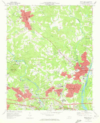 1970 Mount Holly1972 Print · USGSGaston County’s textile and rail corridor thrives in the early seventies, centered on the Catawba River and the bustling hub of Mount Holly. Genealogists can trace family landmarks like Hillcrest Cem and Belmont Abbey College or follow the path of the Seaboard Coast Line.
 - 1973 Map of Belmont, 1976 Print
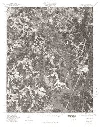
 1973 Belmont1976 Print · USGSThe industrial corridor of Gaston County comes to life in the early seventies, showing the textile centers and river life at the South Carolina border. Trace family roots at Bethesda Ch or Smith Cem, and locate landmarks like Sacred Heart College.
 - 1976 Map of Belmont, 1978 Print
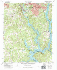
 1976 Belmont1978 Print · USGSGaston County enters the late seventies with its textile towns expanding toward the water. Trace the shoreline of Lake Wylie and identify early suburban growth patterns near Belmont, Cramerton, and Elmore Crossroads.
End of results
Showing maps 1-3 of 3
Top cities near Cramerton
- Charlotte historical maps
- Rock Hill historical maps
- Gastonia historical maps
- Huntersville historical maps
- Fort Mill historical maps
- Cornelius historical maps
See more
Top neighborhoods of Cramerton
Frequently asked questions
- What are the different types of historical maps available for Cramerton?
- What is the oldest map of Cramerton?
- Where can I purchase historical maps of Cramerton for my home or office?
- Where can I download high-res historical maps of Cramerton?
- Are there historical topographic maps available for Cramerton?
- Is there historical aerial imagery available for Cramerton?
- Where are historical maps of Cramerton sourced from?