1900s (20th Century) Maps of Sunbury, North Carolina
Explore 9 historic maps of Sunbury from the 1900s (20th Century). These maps offer a rare glimpse into what life looked like during the 1900s — showing old roads, neighborhoods, homes, and landmarks that have changed or disappeared over time.
Whether you're researching your family's past, planning a metal detecting trip, or studying how Sunbury's landscape evolved across the 1900s, these high-resolution maps are a powerful tool for exploring the history of this region.
- Focus on a specific era: All maps on this page are from the 1900s, giving you a focused view of this time period.
- See what’s changed: Compare century-old streets, trails, and buildings to today's modern landscape using overlays and satellite layers.
- Research with precision: Use these maps for genealogy, historical research, land use analysis, or educational projects.
- View, download, or print: Maps are fully viewable online in high resolution, and can be downloaded or printed for your own records.
Start exploring Sunbury's history through authentic maps from the 1900s. This is your window into the past.
Sunbury, NC maps
(9)- 1906 Map of Beckford
 1906 Beckford1906 Print · USGSCoastal North Carolina at the turn of the century reveals a world of swamp-based industry and riverine commerce. Trace family roots and old landmarks across the landscape from the wharves at Taylor Wharf to crossroads like Wiggins Crossroads and the mills at Merchants Mill Pond.
 - 1907 Map of Beckford
 1907 Beckford1907 Print · USGSNortheastern North Carolina was a landscape of deep swamps and river commerce in the early 1900s. Genealogists can trace family landmarks at Merchants Mill, find rural congregations like Joppa Church, or follow the steam routes past Holidays Island.2 unique versions available
 - 1940 Map of Beckford
 1940 Beckford1940 Print · USGSNortheastern North Carolina in the early 1940s was a land of timbered swamps and essential river crossings. Genealogists and historians can trace old homesteads and transport hubs near Cannon Ferry, Merchants Millpond, and the Beckford Junction rail crossing.2 unique versions available
 - 1953 Map of Norfolk, 1954 Print
 1953 Norfolk1954 Print · USGSCoastal Virginia and northeastern North Carolina appear here during the post-war industrial boom, showing the critical rail-and-sea connections of Hampton Roads. Genealogists can trace family roots through rural landmarks like Gethsemane Ch, the Caledonia State Prison Farm, and the vast interior of the Dismal Swamp.4 unique versions available
 - 1981 Map of Merchants Millpond
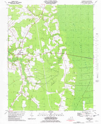
 1981 Merchants Millpond1981 Print · USGSCoastal North Carolina wetlands and rural crossroads define this Gates County landscape in the early eighties. Researchers can trace family sites and community hubs from Gatesville to Easons Crossroads, including local landmarks like Sycamore Hill Ch and the County High Sch.
 - 1981 Map of Sunbury, 1982 Print
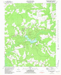
 1981 Sunbury1982 Print · USGSCoastal North Carolina's lowlands are captured here in the early eighties, showing the agricultural settlements on the edge of the great marsh. Trace family history and local landmarks like Sunbury, Oak Grove Ch, and the timber history found along the Old Railroad Grade.
 - 1985 Map of Elizabeth City
 1985 Elizabeth City1985 Print · USGSCoastal North Carolina's rivers and sounds define the landscape of the mid-eighties, from the vast swamps to the historical waterfronts of Elizabeth City and Edenton. Researchers can trace the rail lines of the Southern Ry or locate landmarks like Beaver Hill Cem and South Mills.2 unique versions available
 - 1997 Map of Merchants Millpond, 2000 Print
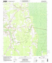
 1997 Merchants Millpond2000 Print · USGSCoastal plain wetlands and rural crossroads define this corner of Gates County during the late twentieth century. Genealogists and local historians can locate several family-named landmarks and old country churches like Lebanon Grove Ch and New Middle Swamp Ch near Easons Crossroads.
 - 1997 Map of Sunbury, 2000 Print
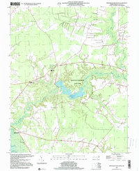
 1997 Sunbury2000 Print · USGSGates County at the edge of the great wetlands in the late twentieth century reveals a landscape shaped by water and woods. Genealogists can trace family names and small settlements from Sunbury to Acorn Hill, or locate the Old Railroad Grade and St Johns Zion Ch.
End of results
Showing maps 1-9 of 9
Top cities near Sunbury
- Arrowhead Beach historical maps
- Winfall historical maps
- Gatesville historical maps
- Harrellsville historical maps
Frequently asked questions
- What are the different types of historical maps available for Sunbury?
- What is the oldest map of Sunbury?
- Where can I purchase historical maps of Sunbury for my home or office?
- Where can I download high-res historical maps of Sunbury?
- Are there historical topographic maps available for Sunbury?
- Is there historical aerial imagery available for Sunbury?
- Where are historical maps of Sunbury sourced from?