1940s Maps of Rymers Ferry, North Carolina
Explore 2 historic maps of Rymers Ferry from the 1940s. These maps offer a rare glimpse into what life looked like during the 1940s — showing old roads, neighborhoods, homes, and landmarks that have changed or disappeared over time.
Whether you're researching your family's past, planning a metal detecting trip, or studying how Rymers Ferry's landscape evolved across the 1940s, these high-resolution maps are a powerful tool for exploring the history of this region.
- Focus on a specific era: All maps on this page are from the 1940s, giving you a focused view of this time period.
- See what’s changed: Compare century-old streets, trails, and buildings to today's modern landscape using overlays and satellite layers.
- Research with precision: Use these maps for genealogy, historical research, land use analysis, or educational projects.
- View, download, or print: Maps are fully viewable online in high resolution, and can be downloaded or printed for your own records.
Start exploring Rymers Ferry's history through authentic maps from the 1940s. This is your window into the past.
Rymers Ferry, NC maps
(2)- 1940 Map of Fontana, 1956 Print
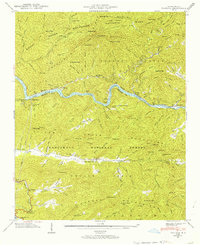 1940 Fontana1956 Print · USGSThe Great Smoky Mountains and Nantahala National Forest meet here just before the era of massive dam projects changed the valley forever. Researchers can trace the Appalachian Trail through the ridges or find the Fontana Copper Mine and Rymer Ferry.2 unique versions available
 - 1941 Map of Fontana
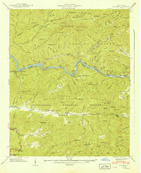 1941 Fontana1941 Print · USGSThe North Carolina mountains meet the Tennessee Valley in this early wartime survey of Graham County and the Smokies. Genealogists and hikers can trace the Appalachian Trail, locate the Fontana Copper Mine, and find the Yellow Creek Cem.
End of results
Showing maps 1-2 of 2
Top cities near Rymers Ferry
- Robbinsville historical maps
- Townsend historical maps
- Lake Santeetlah historical maps
- Fontana Dam historical maps
Frequently asked questions
- What are the different types of historical maps available for Rymers Ferry?
- What is the oldest map of Rymers Ferry?
- Where can I purchase historical maps of Rymers Ferry for my home or office?
- Where can I download high-res historical maps of Rymers Ferry?
- Are there historical topographic maps available for Rymers Ferry?
- Is there historical aerial imagery available for Rymers Ferry?
- Where are historical maps of Rymers Ferry sourced from?