1990s Maps of Butner, North Carolina
Explore 4 historic maps of Butner from the 1990s. These maps offer a rare glimpse into what life looked like during the 1990s — showing old roads, neighborhoods, homes, and landmarks that have changed or disappeared over time.
Whether you're researching your family's past, planning a metal detecting trip, or studying how Butner's landscape evolved across the 1990s, these high-resolution maps are a powerful tool for exploring the history of this region.
- Focus on a specific era: All maps on this page are from the 1990s, giving you a focused view of this time period.
- See what’s changed: Compare century-old streets, trails, and buildings to today's modern landscape using overlays and satellite layers.
- Research with precision: Use these maps for genealogy, historical research, land use analysis, or educational projects.
- View, download, or print: Maps are fully viewable online in high resolution, and can be downloaded or printed for your own records.
Start exploring Butner's history through authentic maps from the 1990s. This is your window into the past.
Butner, NC maps
(4)- 1991 Map of Henderson
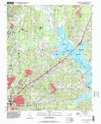
 1991 Henderson1991 Print · USGSThe northern Piedmont and Virginia borderlands come into focus in the early nineties, showing a landscape defined by major reservoirs and growing towns. Trace the rail-and-road connections between Oxford, Henderson, and Durham while exploring the developing shores of Falls Lake.2 unique versions available
 - 1993 Map of Northeast Durham, 1998 Print
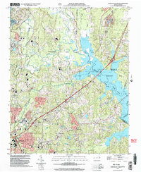
 1993 Northeast Durham1998 Print · USGSThe Durham and Granville county line area comes into focus in the early nineties as the Neuse River basin transforms into a recreation hub. Genealogists and local historians can trace family-named sites like Fairntosh, Gorman, and the Oak Grove Mem Gardens Cem.
 - 1998 Map of Creedmoor, 2000 Print
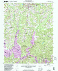 1998 Creedmoor2000 Print · USGSIn the late nineties, the area surrounding Creedmoor shows a landscape balancing small-town life with massive conservation tracts. Genealogists and historians can trace rail-side settlements like Northside and old community landmarks like New Light Ch and Ledge Rock.
 - 1999 Map of Northeast Durham, 2003 Print
 1999 Northeast Durham2003 Print · USGSThe outskirts of Durham and the newly established recreation areas around Falls Lake are captured here at the end of the century. Trace the growth of communities like Gorman and locate family landmarks including Oak Grove Mem Gardens Cem and Union Chapel.
End of results
Showing maps 1-4 of 4
Top cities near Butner
- Raleigh historical maps
- Durham historical maps
- Wake Forest historical maps
- Roxboro historical maps
- Oxford historical maps
- Creedmoor historical maps
See more
Top neighborhoods of Butner
Frequently asked questions
- What are the different types of historical maps available for Butner?
- What is the oldest map of Butner?
- Where can I purchase historical maps of Butner for my home or office?
- Where can I download high-res historical maps of Butner?
- Are there historical topographic maps available for Butner?
- Is there historical aerial imagery available for Butner?
- Where are historical maps of Butner sourced from?