1970s Maps of Butner, North Carolina
Explore 4 historic maps of Butner from the 1970s. These maps offer a rare glimpse into what life looked like during the 1970s — showing old roads, neighborhoods, homes, and landmarks that have changed or disappeared over time.
Whether you're researching your family's past, planning a metal detecting trip, or studying how Butner's landscape evolved across the 1970s, these high-resolution maps are a powerful tool for exploring the history of this region.
- Focus on a specific era: All maps on this page are from the 1970s, giving you a focused view of this time period.
- See what’s changed: Compare century-old streets, trails, and buildings to today's modern landscape using overlays and satellite layers.
- Research with precision: Use these maps for genealogy, historical research, land use analysis, or educational projects.
- View, download, or print: Maps are fully viewable online in high resolution, and can be downloaded or printed for your own records.
Start exploring Butner's history through authentic maps from the 1970s. This is your window into the past.
Butner, NC maps
(4)- 1973 Map of Northeast Durham, 1975 Print
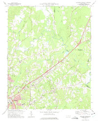 1973 Northeast Durham1975 Print · USGSNortheast of Durham in the early seventies, the landscape was defined by the merging of the Eno and Neuse rivers. Genealogists can trace family names at Oak Grove Memorial Gardens or locate rural landmarks like Gorman, Fairntosh, and Union Chapel.4 unique versions available
 - 1974 Map of Creedmoor, 1977 Print
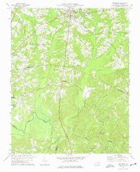 1974 Creedmoor1977 Print · USGSGranville and Wake Counties are shown during the mid-seventies, centered on the transit and agricultural hub of Creedmoor. Genealogists and historians can locate rural landmarks like New Light Ch, Sandy Plain, and the Seaboard Coast Line Railroad.6 unique versions available
 - 1974 Map of Stem, 1977 Print
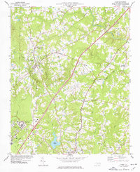 1974 Stem1977 Print · USGSGranville County in the mid-1970s reveals a landscape of rural hamlets and institutional centers interconnected by two major rail lines. Researchers can trace family roots through numerous country churches like Tallyho Ch or locate legacy sites like the Murdoch Center and Lake Rogers.2 unique versions available
 - 1977 Map of Lake Michie
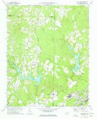 1977 Lake Michie1977 Print · USGSThe Flat River valley in the late seventies reveals a landscape of growing towns and significant public institutions between Durham and Granville. Researchers can trace the footprints of Bahama and Butner, alongside family landmarks like the Carrington Cem and Ellis Chapel.2 unique versions available
End of results
Showing maps 1-4 of 4
Top cities near Butner
- Raleigh historical maps
- Durham historical maps
- Wake Forest historical maps
- Roxboro historical maps
- Oxford historical maps
- Creedmoor historical maps
See more
Top neighborhoods of Butner
Frequently asked questions
- What are the different types of historical maps available for Butner?
- What is the oldest map of Butner?
- Where can I purchase historical maps of Butner for my home or office?
- Where can I download high-res historical maps of Butner?
- Are there historical topographic maps available for Butner?
- Is there historical aerial imagery available for Butner?
- Where are historical maps of Butner sourced from?