1990s Maps of Guilford County, North Carolina
Explore 6 historic maps of Guilford County from the 1990s. These maps offer a rare glimpse into what life looked like during the 1990s — showing old roads, neighborhoods, homes, and landmarks that have changed or disappeared over time.
Whether you're researching your family's past, planning a metal detecting trip, or studying how Guilford County's landscape evolved across the 1990s, these high-resolution maps are a powerful tool for exploring the history of this region.
- Focus on a specific era: All maps on this page are from the 1990s, giving you a focused view of this time period.
- See what’s changed: Compare century-old streets, trails, and buildings to today's modern landscape using overlays and satellite layers.
- Research with precision: Use these maps for genealogy, historical research, land use analysis, or educational projects.
- View, download, or print: Maps are fully viewable online in high resolution, and can be downloaded or printed for your own records.
Start exploring Guilford County's history through authentic maps from the 1990s. This is your window into the past.
Guilford County, NC maps
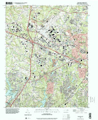
(6)- 1993 Map of High Point West, 1999 Print
 1993 High Point West1999 Print · USGSThe industrial corridor between Davidson and Guilford counties is shown here during the late twentieth century. Genealogists and local historians can trace the growth of High Point and Thomasville, locating landmarks from Westchester Academy to Hedgecock Chapel.
 - 1993 Map of High Point East, 1999 Print
 1993 High Point East1999 Print · USGSCentral North Carolina settlement and development are charted here as the suburbs of HIGH POINT reach into the surrounding countryside. Genealogists can trace family footprints through sites like Green Hill Cem, McCain Sch, and churches such as Friendly Ch.
 - 1997 Map of Bethany, 2000 Print
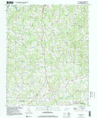
 1997 Bethany2000 Print · USGSThe rural landscape of Rockingham and Guilford counties is preserved here in the late 1990s, centered on several local junctions. Family historians and researchers can trace longstanding community anchors like Wittys Crossroads, Bethany, and Howards Chapel Cem.
 - 1997 Map of Ellisboro, 2000 Print
 1997 Ellisboro2000 Print · USGSSouthern Rockingham County in the late 1990s is captured here, showing the rural communities of Ellisboro and Intelligence near the Dan River. Genealogists can locate numerous landmarks including Kallam Grove Ch, Gideon Ch, and Woodland Cem.
 - 1997 Map of Guilford, 2001 Print
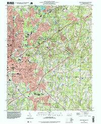
 1997 Guilford2001 Print · USGSThe Greensboro and High Point periphery in the late nineties shows a landscape of rapid suburban growth and established educational roots. Genealogists and local historians can trace community landmarks like Guilford College, Raleigh Crossroads Ch, and Guilford Memorial Park.
 - 1997 Map of Greensboro, 2001 Print
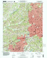
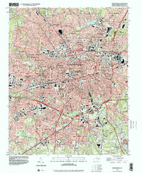 1997 Greensboro2001 Print · USGSGreensboro and its surrounding mill villages appear at a peak of late-century development, blending urban density with historic industrial neighborhoods. Genealogists and historians can trace family roots through specific sites like Bennett College, White Oak, and Pomona.
End of results
Showing maps 1-6 of 6
Top cities of Guilford County
- Greensboro historical maps
- High Point historical maps
- Summerfield historical maps
- Pleasant Garden historical maps
- Oak Ridge historical maps
- Jamestown historical maps
See more
Frequently asked questions
- What are the different types of historical maps available for Guilford County?
- What is the oldest map of Guilford County?
- Where can I purchase historical maps of Guilford County for my home or office?
- Where can I download high-res historical maps of Guilford County?
- Are there historical topographic maps available for Guilford County?
- Is there historical aerial imagery available for Guilford County?
- Where are historical maps of Guilford County sourced from?