1900s (20th Century) Maps of Dunn, North Carolina
Explore 7 historic maps of Dunn from the 1900s (20th Century). These maps offer a rare glimpse into what life looked like during the 1900s — showing old roads, neighborhoods, homes, and landmarks that have changed or disappeared over time.
Whether you're researching your family's past, planning a metal detecting trip, or studying how Dunn's landscape evolved across the 1900s, these high-resolution maps are a powerful tool for exploring the history of this region.
- Focus on a specific era: All maps on this page are from the 1900s, giving you a focused view of this time period.
- See what’s changed: Compare century-old streets, trails, and buildings to today's modern landscape using overlays and satellite layers.
- Research with precision: Use these maps for genealogy, historical research, land use analysis, or educational projects.
- View, download, or print: Maps are fully viewable online in high resolution, and can be downloaded or printed for your own records.
Start exploring Dunn's history through authentic maps from the 1900s. This is your window into the past.
Dunn, NC maps
(7)- 1953 Map of Raleigh, 1965 Print
 1953 Raleigh1965 Print · USGSCentral North Carolina in the early sixties shows a landscape of growing towns and military hubs before the full expansion of the interstate system. Genealogists can trace family footprints across the Piedmont through Wake Forest, Siler City, and the large Fort Bragg Military Reservation.4 unique versions available
 - 1954 Map of Raleigh
 1954 Raleigh1954 Print · USGSThe North Carolina Piedmont and Sandhills are captured in the mid-fifties during a period of steady regional growth. Genealogists and historians can trace the development of towns like Siler City or locate landmarks such as Falls of Neuse and Camp Mackall.
 - 1973 Map of Dunn, 1975 Print
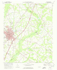 1973 Dunn1975 Print · USGSDunn and Benson were thriving railroad and agricultural hubs in the early 1970s. Genealogists and local historians can trace family church roots at Jonesboro Ch and Mingo Hill Ch or locate landmarks like the Young Lookout Tower.2 unique versions available
 - 1973 Map of Erwin, 1975 Print
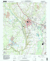
 1973 Erwin1975 Print · USGSHarnett and Cumberland Counties are captured in the early seventies as the Cape Fear and Little Rivers meet amid a landscape of small-town industry. Genealogists can trace family connections through the Averasboro Cem, Turlington Grove Ch, and the streets of Erwin.2 unique versions available
 - 1986 Map of Fayetteville
 1986 Fayetteville1986 Print · USGSThe North Carolina coastal plain appears in the mid-1980s as a bustling corridor of military installations and historic tobacco towns. Genealogists and historians can trace the footprints of Fort Bragg Military Reservation, Campbell University, and the rail lines of the Seaboard Coast Line RR.2 unique versions available
 - 1997 Map of Erwin, 2000 Print
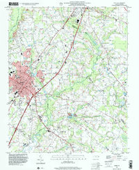
 1997 Erwin2000 Print · USGSThe confluence of the Cape Fear River and Little River anchors this North Carolina landscape during the late nineties. Researchers can trace historic church sites like Erwin Chapel and Smith Grove Ch or locate family burial grounds including Greenwood Cem and Averasboro Cem.
 - 1997 Map of Dunn, 2000 Print
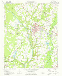
 1997 Dunn2000 Print · USGSThe area surrounding Dunn and Benson is captured in the late nineties, documenting a landscape of rural crossroads and established schools. Researchers can trace family sites at Mary Stewart Sch, Savannah Hill Ch, or the Mingo Primitive Ch.
End of results
Showing maps 1-7 of 7
Top cities near Dunn
- Fayetteville historical maps
- Smithfield historical maps
- Erwin historical maps
- Angier historical maps
- Benson historical maps
- Lillington historical maps
See more
Top neighborhoods of Dunn
Frequently asked questions
- What are the different types of historical maps available for Dunn?
- What is the oldest map of Dunn?
- Where can I purchase historical maps of Dunn for my home or office?
- Where can I download high-res historical maps of Dunn?
- Are there historical topographic maps available for Dunn?
- Is there historical aerial imagery available for Dunn?
- Where are historical maps of Dunn sourced from?