1940s Maps of Addie, North Carolina
Explore 2 historic maps of Addie from the 1940s. These maps offer a rare glimpse into what life looked like during the 1940s — showing old roads, neighborhoods, homes, and landmarks that have changed or disappeared over time.
Whether you're researching your family's past, planning a metal detecting trip, or studying how Addie's landscape evolved across the 1940s, these high-resolution maps are a powerful tool for exploring the history of this region.
- Focus on a specific era: All maps on this page are from the 1940s, giving you a focused view of this time period.
- See what’s changed: Compare century-old streets, trails, and buildings to today's modern landscape using overlays and satellite layers.
- Research with precision: Use these maps for genealogy, historical research, land use analysis, or educational projects.
- View, download, or print: Maps are fully viewable online in high resolution, and can be downloaded or printed for your own records.
Start exploring Addie's history through authentic maps from the 1940s. This is your window into the past.
Addie, NC maps
(2)- 1941 Map of Addie
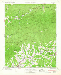 1941 Addie1941 Print · USGSJackson County's mountain settlements and rail corridors are captured here just before the mid-century, centered on the Southern railroad route. Researchers can trace family sites like Norman Cem or locate community centers at Liberty Sch and Ochre Hill Ch.2 unique versions available
 - 1942 Map of Addie
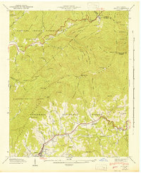 1942 Addie1942 Print · USGSJackson County's mountain communities and the Southern railroad corridor are captured here in the early 1940s. Researchers can locate family landmarks like Norman Cem or trace the early development of Sylva, Addie, and Willits.
End of results
Showing maps 1-2 of 2
Top cities near Addie
- Waynesville historical maps
- Cullowhee historical maps
- Franklin historical maps
- Sylva historical maps
- Cherokee historical maps
- Maggie Valley historical maps
See more
Frequently asked questions
- What are the different types of historical maps available for Addie?
- What is the oldest map of Addie?
- Where can I purchase historical maps of Addie for my home or office?
- Where can I download high-res historical maps of Addie?
- Are there historical topographic maps available for Addie?
- Is there historical aerial imagery available for Addie?
- Where are historical maps of Addie sourced from?