1980s Maps of Overshot, North Carolina
Explore 2 historic maps of Overshot from the 1980s. These maps offer a rare glimpse into what life looked like during the 1980s — showing old roads, neighborhoods, homes, and landmarks that have changed or disappeared over time.
Whether you're researching your family's past, planning a metal detecting trip, or studying how Overshot's landscape evolved across the 1980s, these high-resolution maps are a powerful tool for exploring the history of this region.
- Focus on a specific era: All maps on this page are from the 1980s, giving you a focused view of this time period.
- See what’s changed: Compare century-old streets, trails, and buildings to today's modern landscape using overlays and satellite layers.
- Research with precision: Use these maps for genealogy, historical research, land use analysis, or educational projects.
- View, download, or print: Maps are fully viewable online in high resolution, and can be downloaded or printed for your own records.
Start exploring Overshot's history through authentic maps from the 1980s. This is your window into the past.
Overshot, NC maps
(2)- 1986 Map of Newton Grove North
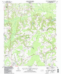 1986 Newton Grove North1986 Print · USGSCoastal Plain farmland meets civil war history in this mid-1980s survey of the Johnston and Sampson county border. Genealogists can trace family landmarks and rural congregations like Strickland Crossroads, Bentonville, and Antioch Ch.
 - 1986 Map of Fayetteville
 1986 Fayetteville1986 Print · USGSThe North Carolina coastal plain appears in the mid-1980s as a bustling corridor of military installations and historic tobacco towns. Genealogists and historians can trace the footprints of Fort Bragg Military Reservation, Campbell University, and the rail lines of the Seaboard Coast Line RR.2 unique versions available
End of results
Showing maps 1-2 of 2
Top cities near Overshot
- Smithfield historical maps
- Dunn historical maps
- Selma historical maps
- Benson historical maps
- Four Oaks historical maps
- Pine Level historical maps
See more
Frequently asked questions
- What are the different types of historical maps available for Overshot?
- What is the oldest map of Overshot?
- Where can I purchase historical maps of Overshot for my home or office?
- Where can I download high-res historical maps of Overshot?
- Are there historical topographic maps available for Overshot?
- Is there historical aerial imagery available for Overshot?
- Where are historical maps of Overshot sourced from?