1980s Maps of Lenoir County, North Carolina
Explore 15 historic maps of Lenoir County from the 1980s. These maps offer a rare glimpse into what life looked like during the 1980s — showing old roads, neighborhoods, homes, and landmarks that have changed or disappeared over time.
Whether you're researching your family's past, planning a metal detecting trip, or studying how Lenoir County's landscape evolved across the 1980s, these high-resolution maps are a powerful tool for exploring the history of this region.
- Focus on a specific era: All maps on this page are from the 1980s, giving you a focused view of this time period.
- See what’s changed: Compare century-old streets, trails, and buildings to today's modern landscape using overlays and satellite layers.
- Research with precision: Use these maps for genealogy, historical research, land use analysis, or educational projects.
- View, download, or print: Maps are fully viewable online in high resolution, and can be downloaded or printed for your own records.
Start exploring Lenoir County's history through authentic maps from the 1980s. This is your window into the past.
Lenoir County, NC maps
(15)- 1980 Map of Seven Springs
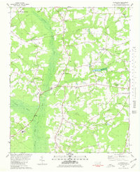
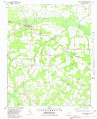 1980 Seven Springs1980 Print · USGSCoastal plain life in eastern North Carolina comes into focus during the late seventies, centered on the oxbows of the Neuse River. Genealogists and historians can trace community roots at Outlaws Bridge, Husseys Crossroads, and the grounds of New Jerusalem Ch.
 - 1980 Map of Pink Hill, 1981 Print
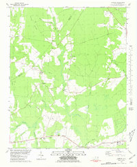
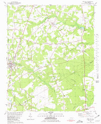 1980 Pink Hill1981 Print · USGSThe rural crossroads of Duplin and Lenoir counties are captured in the early eighties as agricultural traditions met modern aviation. Researchers can trace family history through sites like Lawsons Mill, Whaleys Chapel, and the community at Jonestown.
 - 1980 Map of Deep Run, 1981 Print
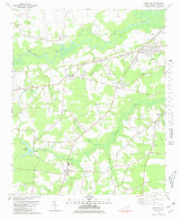 1980 Deep Run1981 Print · USGSCoastal plain farming and river life define Lenoir County in the early eighties. Genealogists and local historians can trace family-named sites like Albrittons and Bucklesberry, or locate historic gathering places like Tulls Mill and Webbs Chapel.
 - 1980 Map of Rivermont, 1981 Print
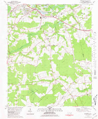 1980 Rivermont1981 Print · USGSSoutheast of Kinston in the late 1970s, the rural reaches of Lenoir County remain defined by the winding Neuse River and the deep wetlands of the Pocosin. Researchers can trace family-named sites like Parrott Fork and Loftins Crossroads or locate Patterson Chapel and Southview Cem.
 - 1980 Map of Albertson, 1981 Print
 1980 Albertson1981 Print · USGSCoastal plain wetlands and rural settlements define the Duplin County landscape in the early eighties. Genealogists and local historians can trace family roots through numerous small communities like Albertson and Kornegay, alongside several community landmarks such as Grady High Sch and Piney Grove Ch.
 - 1980 Map of Comfort, 1981 Print
 1980 Comfort1981 Print · USGSJones and Lenoir County rural life in the late seventies centers on the meandering Trent River and its surrounding wetlands. Genealogists and local historians can trace family-named sites and historic congregations like Quaker House Ch, Taylors Corner, and Pleasant Hill.
 - 1982 Map of Hookerton, 1983 Print
 1982 Hookerton1983 Print · USGSCoastal plain life in the early eighties centered around the meandering Contentnea Creek and its surrounding pocosin wetlands. Genealogists and local historians can trace family locations near Hookerton, Maury, and numerous rural landmarks like Saints Delight Ch and East Greene Sch.
 - 1982 Map of Dover, 1983 Print
 1982 Dover1983 Print · USGSDover and the northern reaches of the Great Dover Swamp appear here in the early eighties, centered on the railroad corridor. Local historians can trace family-named landmarks like Sassers Mill and Foys Ch, or locate rural churches including Queen Chapel and Holly Branch Ch.
 - 1982 Map of Snow Hill, 1983 Print
 1982 Snow Hill1983 Print · USGSGreene County agriculture and community life are centered on the banks of Contentnea Creek in the early eighties. Genealogists and local historians can trace family ties through numerous rural landmarks like McCoy Chapel, Arba Ch, and the crossroads at Bests.
 - 1982 Map of Ayden, 1983 Print
 1982 Ayden1983 Print · USGSNorth Carolina's eastern coastal plain is captured here in the early eighties as the Seaboard Coast Line linked thriving rail towns. Genealogists and local historians can trace family roots through numerous country landmarks like Jackson Cem, Little Cr Ch, and the settlement of Hanrahan.
 - 1983 Map of Kinston
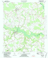
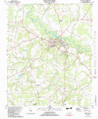
 1983 Kinston1983 Print · USGSIn the early eighties, the city of Kinston stands as a vibrant regional center at the meeting of the Neuse River and major rail lines. Genealogists and historians can trace community roots through landmarks like Maplewood Cem, Grainger Stadium, and the Caswell Center.
 - 1983 Map of Grifton
 1983 Grifton1983 Print · USGSThe river-driven landscape of eastern North Carolina is captured here in the early 1980s as it spans three county lines. Genealogists can trace family roots through numerous rural landmarks like Alum Springs Ch, British Chapel, and the settlement of Tick Bite.
 - 1983 Map of Falling Creek
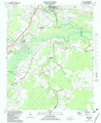
 1983 Falling Creek1983 Print · USGSThe Lenoir County countryside comes into focus in the early eighties as a network of rail-side settlements and swamp-fed lowlands. Genealogists and local historians can trace family roots through Pinelawn Cem and Temple Israel Cem or locate the Kennedy Mem Home and Falling Creek Station.
 - 1983 Map of La Grange
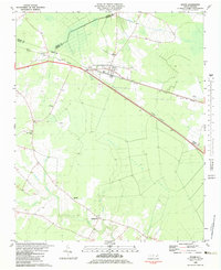
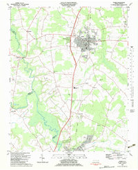
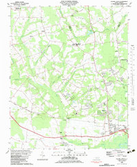
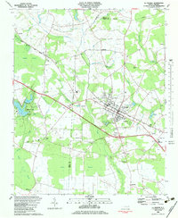 1983 La Grange1983 Print · USGSThe town of La Grange and its surrounding crossroads are captured here in the early eighties. Genealogists and local historians can trace the rural church network, including Jackson Chapel and White Oak Grove Ch, or locate small settlements like Best and Little Baltimore.
 - 1985 Map of Kinston
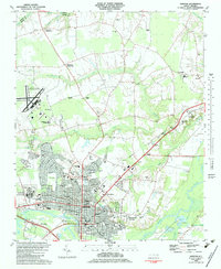
 1985 Kinston1985 Print · USGSCoastal plain life and Cold War infrastructure meet in the mid-eighties as the Neuse River winds through agricultural heartlands. Researchers can locate family landmarks like Falling Creek Cem, old milling sites such as Tulls Mill, and the massive Voice of America Radio Towers.2 unique versions available
End of results
Showing maps 1-15 of 15
Top cities of Lenoir County
Frequently asked questions
- What are the different types of historical maps available for Lenoir County?
- What is the oldest map of Lenoir County?
- Where can I purchase historical maps of Lenoir County for my home or office?
- Where can I download high-res historical maps of Lenoir County?
- Are there historical topographic maps available for Lenoir County?
- Is there historical aerial imagery available for Lenoir County?
- Where are historical maps of Lenoir County sourced from?