1910s Maps of Old Farm, Kinston
Explore 2 historic maps of Old Farm from the 1910s. These maps offer a rare glimpse into what life looked like during the 1910s — showing old roads, neighborhoods, homes, and landmarks that have changed or disappeared over time.
Whether you're researching your family's past, planning a metal detecting trip, or studying how Old Farm's landscape evolved across the 1910s, these high-resolution maps are a powerful tool for exploring the history of this region.
- Focus on a specific era: All maps on this page are from the 1910s, giving you a focused view of this time period.
- See what’s changed: Compare century-old streets, trails, and buildings to today's modern landscape using overlays and satellite layers.
- Research with precision: Use these maps for genealogy, historical research, land use analysis, or educational projects.
- View, download, or print: Maps are fully viewable online in high resolution, and can be downloaded or printed for your own records.
Start exploring Old Farm's history through authentic maps from the 1910s. This is your window into the past.
Old Farm, Kinston maps
(2)- 1914 Map of Kinston
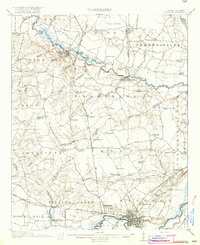
 1914 Kinston1914 Print · USGSBefore the onset of the First World War, the rural landscape of eastern North Carolina was a dense network of railroad sidings, country schools, and pocosin wetlands. Genealogists can trace family landmarks and forgotten settlements like Hookerton, Suggs Siding, and Saints Delight Church.3 unique versions available
 - 1916 Map of Kinston
 1916 Kinston1916 Print · USGSThe Neuse River and Contentnea Creek basins are shown here during the mid-1910s, capturing the transition of eastern North Carolina's rural landscape. Genealogists can locate family landmarks like Suggs School, Beulah Church, and Mewborns Crossroads.3 unique versions available
End of results
Showing maps 1-2 of 2
Top cities near Old Farm
- Greenville historical maps
- Kinston historical maps
- Ayden historical maps
- Winterville historical maps
- La Grange historical maps
- Snow Hill historical maps
See more
Frequently asked questions
- What are the different types of historical maps available for Old Farm?
- What is the oldest map of Old Farm?
- Where can I purchase historical maps of Old Farm for my home or office?
- Where can I download high-res historical maps of Old Farm?
- Are there historical topographic maps available for Old Farm?
- Is there historical aerial imagery available for Old Farm?
- Where are historical maps of Old Farm sourced from?