1940s Maps of Berry Mill, North Carolina
Explore 2 historic maps of Berry Mill from the 1940s. These maps offer a rare glimpse into what life looked like during the 1940s — showing old roads, neighborhoods, homes, and landmarks that have changed or disappeared over time.
Whether you're researching your family's past, planning a metal detecting trip, or studying how Berry Mill's landscape evolved across the 1940s, these high-resolution maps are a powerful tool for exploring the history of this region.
- Focus on a specific era: All maps on this page are from the 1940s, giving you a focused view of this time period.
- See what’s changed: Compare century-old streets, trails, and buildings to today's modern landscape using overlays and satellite layers.
- Research with precision: Use these maps for genealogy, historical research, land use analysis, or educational projects.
- View, download, or print: Maps are fully viewable online in high resolution, and can be downloaded or printed for your own records.
Start exploring Berry Mill's history through authentic maps from the 1940s. This is your window into the past.
Berry Mill, NC maps
(2)- 1946 Map of Corbin Knob, 1957 Print
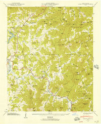 1946 Corbin Knob1957 Print · USGSMacon County mountain life is detailed here just after the war, showing the area surrounding the town of Franklin. Genealogists can locate family landmarks including Anbel Cem, Sloans Chapel, and early schools like Walnut Creek Sch.6 unique versions available
 - 1947 Map of Corbin Knob
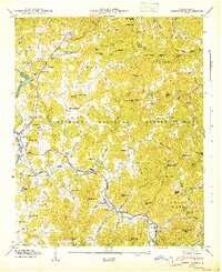 1947 Corbin Knob1947 Print · USGSMacon County in the late 1940s reveals a mountain landscape of deep river valleys and family-named peaks within the Nantahala National Forest. Researchers can trace rural school systems at Oak Ridge Sch and Higdon Sch or locate the ancient Nikwasi Indian Mound.2 unique versions available
End of results
Showing maps 1-2 of 2
Top cities near Berry Mill
- Cullowhee historical maps
- Franklin historical maps
- Sylva historical maps
- Webster historical maps
- Forest Hills historical maps
- Dillard historical maps
See more
Frequently asked questions
- What are the different types of historical maps available for Berry Mill?
- What is the oldest map of Berry Mill?
- Where can I purchase historical maps of Berry Mill for my home or office?
- Where can I download high-res historical maps of Berry Mill?
- Are there historical topographic maps available for Berry Mill?
- Is there historical aerial imagery available for Berry Mill?
- Where are historical maps of Berry Mill sourced from?