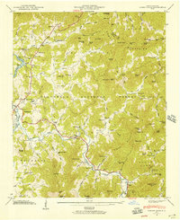
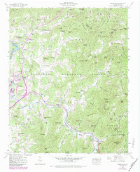
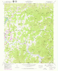
1946 Map of Corbin Knob
USGS Topo · Published 1957About this map
The Little Tennessee River and Cullasaja River define the local topography of this 1946 survey, converging just south of Franklin. The landscape is a network of mid-century rural infrastructure, featuring the Porters Bend Dam creating Lake Emory and the ancient presence of the Nikwasi Indian Mound. Numerous small schools and churches, such as Oak Ridge Sch, Salem Sch, and Bethlehem Ch, serve the dispersed mountain communities of Ellijay and Sugar Fork. Local industry and geology are noted through features like Berry Mill and Corundum Hill near the southern bend of the Cullasaja River. Much of the eastern and central portion of the map is protected land within the Nantahala National Forest, where high peaks like Corbin Knob and Onion Mtn separate the Savannah and Mill Shoal watersheds.
Find a feature on this map
107 named features on this map. Tap any name to fly to it.
Don’t see what you’re looking for? This feature index may not catch every label — zoom into the map to look around manually.
Map Details
Editions of this 1946 Corbin Knob Map
6 editions found
Other maps of this area

1891 · Cowee
USGS Topo · 1:125,000

1897 · Cowee
USGS Topo · 1:125,000

1907 · Cowee
USGS Topo · 1:125,000

1933 · Bryson
USGS Topo · 1:62,500

1935 · Franklin
USGS Topo · 1:24,000

1935 · Prentiss
USGS Topo · 1:24,000

1935 · Cullowhee
USGS Topo · 1:24,000

1935 · Scaly
USGS Topo · 1:24,000

1935 · Glenville
USGS Topo · 1:24,000

1935 · Corbin Knob
USGS Topo · 1:24,000