Old Maps of Macon County, North Carolina for Metal Detecting
Plan your next treasure hunt with 174 historic maps of Macon County. Find old homesites, ghost towns, trails, and gathering spots that may be lost to time — perfect for identifying promising metal detecting locations.
- Locate forgotten sites: Uncover places like long-lost settlements, abandoned rail lines, or gathering spots.
- Plan better hunts: Use map overlays combined with LiDAR or satellite views to narrow in on historically rich areas.
- Made for detectorists: Thousands of hobbyists use these maps to discover relics, coins, and hidden history.
Use these historic maps to boost your research and find new opportunities beneath the surface of Macon County.
Macon County, NC maps
(174)- 1886 Map of Dahlonega
 1886 Dahlonega1886 Print · USGSThe North Georgia mountains in the mid-1880s reveal a landscape of mining camps and early settlements before the modern era. Genealogists and historians can trace family-named landmarks like Helton's Field and Osbornes, or locate the Findley Mine and the Indian Mound.
 - 1886 Map of Walhalla
 1886 Walhalla1886 Print · USGSThe foothills of the Blue Ridge come alive in this late nineteenth-century survey of the Georgia and South Carolina borderlands. Genealogists and historians can trace the early rail networks through Walhalla and Toccoa, or locate family landmarks like Batchelor's Retreat and Mosley's Mill.
 - 1891 Map of Cowee
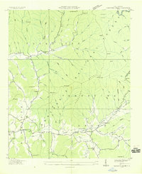
 1891 Cowee1891 Print · USGSWestern North Carolina's high mountain reaches are captured here in the late nineteenth century as the railroad began to transform the region. Trace early transport routes like the Western North Carolina Railroad and Cowee Tunnel alongside old settlements at Franklin and Quallatown.
 - 1892 Map of Dahlonega
 1892 Dahlonega1892 Print · USGSThe North Georgia mountains come alive in the late nineteenth century, showing the rugged terrain around the mining hub of Dahlonega. Genealogists and historians can trace family-named sites like Osbornes, find the elusive Gold Mine, and locate the Indian Mound.2 unique versions available
 - 1892 Map of Walhalla
 1892 Walhalla1892 Print · USGSThe tri-state border region of Georgia and the Carolinas comes alive in this late nineteenth-century survey. Genealogists and historians can trace family-named landmarks like Young Davis's or locate river crossings like Jenkins's Ferry and the Bachelors Retreat P.O.7 unique versions available
 - 1896 Map of Walhalla
 1896 Walhalla1896 Print · USGSThe tri-state mountain country comes alive in this late 1800s survey of the Oconee and Habersham borderlands. Researchers can trace early river commerce and transit through Ramsey Ferry, the tracks of the Blue Ridge Railroad, and the industrial site of Mosley Mill.
 - 1896 Map of Dahlonega
 1896 Dahlonega1896 Print · USGSThe Blue Ridge and North Georgia gold belt are shown here in the 1890s, when mining and mountain gaps defined local travel. Genealogists can trace family roots in Dahlonega, Porter Springs, and the Findley Mine or locate early settlements like Nacoochee.
 - 1897 Map of Cowee
 1897 Cowee1897 Print · USGSThe Great Smoky Mountains and Blue Ridge foothills appear here in the 1890s, when the railroad first began to penetrate the high gaps. Trace family roots and mountain industry through old settlements like Quallatown, Sylva, and the Cowee Tunnel engineering site.4 unique versions available
 - 1903 Map of Dahlonega
 1903 Dahlonega1903 Print · USGSNorth Georgia and the Blue Ridge were defined by mountain settlements and early industry at the turn of the century. Genealogists and historians can trace family locations across the Nacoochee Valley, locate the Asbestos Mines, or find old sites like Loudsville and Porter Springs.5 unique versions available
 - 1907 Map of Cowee
 1907 Cowee1907 Print · USGSWestern North Carolina at the turn of the century shows a landscape of rail-connected river towns and high mountain gaps. Genealogists can trace early homesteads and industry through landmarks like West Mill, Roanes Mill, and the many settlements along the Southern Railway.5 unique versions available
 - 1933 Map of Bryson
 1933 Bryson1933 Print · USGSThe mountain valleys of Swain County are captured in the early 1930s, showing the early settlement patterns of the Great Smoky Mountains. Genealogists and historians can trace community roots through schoolhouses like Lands Creek Sch and Indian Creek Sch.
 - 1933 Map of Bushnell
 1933 Bushnell1933 Print · USGSSwain County high country in the late 1920s is defined by a remote landscape of steep ridges and small mountain schools. Researchers can trace the locations of Mill Creek Sch and School No 2 or identify family landmarks like Loudermilk Ridge and Welch Bald.
 - 1935 Map of Franklin
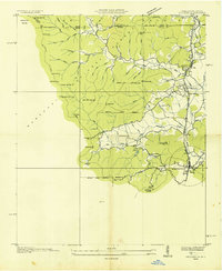
 1935 Franklin1935 Print · USGSMacon County's mountain valleys and river bends are captured here in the mid-1930s just as the TVA began shaping the region. Genealogists and local historians can trace rural homesteads near Louisa Chapel, Burningtown School, and the Franklin Cem.
 - 1935 Map of Rainbow Springs
 1935 Rainbow Springs1935 Print · USGSThe Macon County backcountry in the mid-1930s shows an active logging era as timber lines competed with the rising National Forest. Map collectors and genealogists can locate the CCC Camp No F 12, the logging path of the Lumber Company RR, and the Rainbow Sch.
 - 1935 Map of Prentiss
 1935 Prentiss1935 Print · USGSMacon County in the mid-1930s shows a landscape of high ridges and narrow valleys where the forestry economy was taking root. Genealogists and researchers can locate numerous rural landmarks like Mulberry Sch, Coweeta Ch, and the Tallulah Falls Railroad.
 - 1935 Map of Cashiers
 1935 Cashiers1935 Print · USGSJackson County and the North Carolina-South Carolina border appear here in the mid-1930s as modern surveying techniques were first being applied. Researchers can trace early state infrastructure such as St Hy No 106 as it passes through the Nantahala National Forest.
 - 1935 Map of Shooting Creek
 1935 Shooting Creek1935 Print · USGSClay County mountain life is recorded in this mid-1930s survey of the high ridges and deep coves. Genealogists can locate family landmarks like Tidwell Sch, Marshall Chapel, and the community at Tusquitee long before modern road improvements.
 - 1935 Map of Burningtown Bald
 1935 Burningtown Bald1935 Print · USGSMacon County's high ridges and deep coves are captured in the mid-1930s, showing the early infrastructure of the Nantahala National Forest. Researchers can trace the original path of the Appalachian Trail past the Wayah Bald Fire Tower and locate local landmarks like Mt Sinai Ch and the Corundum No 1 mine.
 - 1935 Map of Dillard
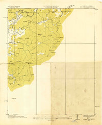
 1935 Dillard1935 Print · USGSThe Georgia and North Carolina borderlands are captured here in the mid-1930s as the rail and highway networks expanded through the mountains. Researchers can locate the Rabun Gap Nacoochee Sch, trace the Tallulah Falls RR, and find local landmarks like Wolf Fork Ch.
 - 1935 Map of Topton
 1935 Topton1935 Print · USGSWestern North Carolina’s mountain timber and rail landscape is captured here in the mid-thirties as federal relief work takes root. Trace the winding Ritter Lumber RR alongside CCC Camp No F 13 and the remote settlement of Aquone.
 - 1935 Map of Wayah Bald
 1935 Wayah Bald1935 Print · USGSHigh in the Blue Ridge Mountains during the mid-1930s, this survey reveals the isolated homesteads and forest tracts of Macon County. Genealogists can locate family landmarks like Marshall Chapel, Oakdale Sch, and the remote Kyle PO or Flats PO.
 - 1935 Map of Scaly
 1935 Scaly1935 Print · USGSMacon County's high ridges and isolated valleys are captured here during the mid-thirties, showing the rural communities of Scaly and Tessentee. Local historians can locate vanished landmarks like Drymans Chapel, Gold Mine Sch, and early trails through Nickajack Gap.
 - 1935 Map of Rabun Bald
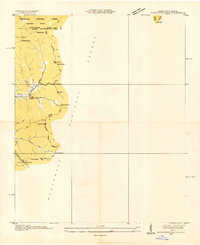
 1935 Rabun Bald1935 Print · USGSThe Georgia and North Carolina high country is captured here during the mid-thirties, dominated by the ridge lines of the Blue Ridge. Researchers can trace old mountain trails to landmarks like the Fire Tower at Rabun Bald or locate family sites near Dillard and Stillhouse Creek.
 - 1935 Map of Hightower Bald
 1935 Hightower Bald1935 Print · USGSThe Georgia and North Carolina high country is captured here in the mid-1930s, showing the ridge-top border and the early Appalachian Trail. Genealogists and hikers can locate the Pleasant Hill School and the settlement of Hightower along the banks of Big Creek.
 - 1935 Map of Glenville
 1935 Glenville1935 Print · USGSJackson County's high mountain settlements and river valleys are shown in the mid-1930s, prior to the major dam projects of the era. Researchers can trace family roots through numerous remote landmarks like Erastus, the Yellow Mtn Sch, and Hamburg Ch.
Showing maps 1-25 of 174
Top cities of Macon County
Frequently asked questions
- What are the different types of historical maps available for Macon County?
- What is the oldest map of Macon County?
- Where can I purchase historical maps of Macon County for my home or office?
- Where can I download high-res historical maps of Macon County?
- Are there historical topographic maps available for Macon County?
- Is there historical aerial imagery available for Macon County?
- Where are historical maps of Macon County sourced from?