1940s Maps of Waverly, North Carolina
Explore 2 historic maps of Waverly from the 1940s. These maps offer a rare glimpse into what life looked like during the 1940s — showing old roads, neighborhoods, homes, and landmarks that have changed or disappeared over time.
Whether you're researching your family's past, planning a metal detecting trip, or studying how Waverly's landscape evolved across the 1940s, these high-resolution maps are a powerful tool for exploring the history of this region.
- Focus on a specific era: All maps on this page are from the 1940s, giving you a focused view of this time period.
- See what’s changed: Compare century-old streets, trails, and buildings to today's modern landscape using overlays and satellite layers.
- Research with precision: Use these maps for genealogy, historical research, land use analysis, or educational projects.
- View, download, or print: Maps are fully viewable online in high resolution, and can be downloaded or printed for your own records.
Start exploring Waverly's history through authentic maps from the 1940s. This is your window into the past.
Waverly, NC maps
(2)- 1946 Map of Barnardsville, 1958 Print
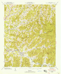 1946 Barnardsville1958 Print · USGSBarnardsville and the surrounding Blue Ridge coves are captured here in the mid-1940s as the Pisgah National Forest boundary meets local farmland. Researchers can trace ancestral locations at Dillingham Cem, find the old Indian Creek Sch, or locate the FFA Camp along the mountain creeks.4 unique versions available
 - 1947 Map of Barnardsville
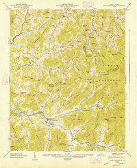 1947 Barnardsville1947 Print · USGSThe mountains of Buncombe and Madison counties are captured here in the mid-1940s. Genealogists can trace family roots through numerous sites like Dillingham Cem, Indian Creek Sch, and the community of Democrat.2 unique versions available
End of results
Showing maps 1-2 of 2
Top cities near Waverly
- Asheville historical maps
- Black Mountain historical maps
- Woodfin historical maps
- Weaverville historical maps
- Mars Hill historical maps
- Burnsville historical maps
See more
Frequently asked questions
- What are the different types of historical maps available for Waverly?
- What is the oldest map of Waverly?
- Where can I purchase historical maps of Waverly for my home or office?
- Where can I download high-res historical maps of Waverly?
- Are there historical topographic maps available for Waverly?
- Is there historical aerial imagery available for Waverly?
- Where are historical maps of Waverly sourced from?