1990s Maps of Dendron, North Carolina
Explore 1 historic maps of Dendron from the 1990s. These maps offer a rare glimpse into what life looked like during the 1990s — showing old roads, neighborhoods, homes, and landmarks that have changed or disappeared over time.
Whether you're researching your family's past, planning a metal detecting trip, or studying how Dendron's landscape evolved across the 1990s, these high-resolution maps are a powerful tool for exploring the history of this region.
- Focus on a specific era: All maps on this page are from the 1990s, giving you a focused view of this time period.
- See what’s changed: Compare century-old streets, trails, and buildings to today's modern landscape using overlays and satellite layers.
- Research with precision: Use these maps for genealogy, historical research, land use analysis, or educational projects.
- View, download, or print: Maps are fully viewable online in high resolution, and can be downloaded or printed for your own records.
Start exploring Dendron's history through authentic maps from the 1990s. This is your window into the past.
Dendron, NC maps
(1)- 1994 Map of Old Fort, 1998 Print
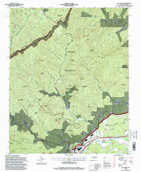 1994 Old Fort1998 Print · USGSWestern North Carolina's high-country transition is captured in the mid-1990s as the Blue Ridge meets the Catawba River valley. Genealogists and hikers can trace family landmarks and backcountry trails through Old Fort, Siloam Cemeteries, and Piney Grove Church.
End of results
Showing maps 1-1 of 1
Top cities near Dendron
- Black Mountain historical maps
- Marion historical maps
- Swannanoa historical maps
- Spruce Pine historical maps
- Lake Lure historical maps
- Old Fort historical maps
See more
Frequently asked questions
- What are the different types of historical maps available for Dendron?
- What is the oldest map of Dendron?
- Where can I purchase historical maps of Dendron for my home or office?
- Where can I download high-res historical maps of Dendron?
- Are there historical topographic maps available for Dendron?
- Is there historical aerial imagery available for Dendron?
- Where are historical maps of Dendron sourced from?