1930s Maps of Upper Pigeonroost, North Carolina
Explore 2 historic maps of Upper Pigeonroost from the 1930s. These maps offer a rare glimpse into what life looked like during the 1930s — showing old roads, neighborhoods, homes, and landmarks that have changed or disappeared over time.
Whether you're researching your family's past, planning a metal detecting trip, or studying how Upper Pigeonroost's landscape evolved across the 1930s, these high-resolution maps are a powerful tool for exploring the history of this region.
- Focus on a specific era: All maps on this page are from the 1930s, giving you a focused view of this time period.
- See what’s changed: Compare century-old streets, trails, and buildings to today's modern landscape using overlays and satellite layers.
- Research with precision: Use these maps for genealogy, historical research, land use analysis, or educational projects.
- View, download, or print: Maps are fully viewable online in high resolution, and can be downloaded or printed for your own records.
Start exploring Upper Pigeonroost's history through authentic maps from the 1930s. This is your window into the past.
Upper Pigeonroost, NC maps
(2)- 1935 Map of Huntdale
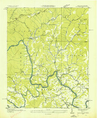 1935 Huntdale1935 Print · USGSThe Nolichucky River valley comes alive in the mid-1930s as the Clinchfield RR winds through the mountains of Mitchell and Yancey Counties. Genealogists and historians can locate dozens of small community hubs including Huntdale, the Brummett Creek Sch, and Jacobs Mill.
 - 1939 Map of Huntdale
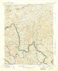 1939 Huntdale1939 Print · USGSThe Nolichucky River valley along the North Carolina and Tennessee border is shown here just before the Second World War. Genealogists can trace family roots through mountain settlements like Huntdale, rural landmarks like Worrick Cem, and the path of the Clinchfield Railroad.5 unique versions available
End of results
Showing maps 1-2 of 2
Top cities near Upper Pigeonroost
- Johnson City historical maps
- Elizabethton historical maps
- Erwin historical maps
- Jonesborough historical maps
- Unicoi historical maps
- Pine Crest historical maps
See more
Frequently asked questions
- What are the different types of historical maps available for Upper Pigeonroost?
- What is the oldest map of Upper Pigeonroost?
- Where can I purchase historical maps of Upper Pigeonroost for my home or office?
- Where can I download high-res historical maps of Upper Pigeonroost?
- Are there historical topographic maps available for Upper Pigeonroost?
- Is there historical aerial imagery available for Upper Pigeonroost?
- Where are historical maps of Upper Pigeonroost sourced from?