1990s Maps of Candor, North Carolina
Explore 2 historic maps of Candor from the 1990s. These maps offer a rare glimpse into what life looked like during the 1990s — showing old roads, neighborhoods, homes, and landmarks that have changed or disappeared over time.
Whether you're researching your family's past, planning a metal detecting trip, or studying how Candor's landscape evolved across the 1990s, these high-resolution maps are a powerful tool for exploring the history of this region.
- Focus on a specific era: All maps on this page are from the 1990s, giving you a focused view of this time period.
- See what’s changed: Compare century-old streets, trails, and buildings to today's modern landscape using overlays and satellite layers.
- Research with precision: Use these maps for genealogy, historical research, land use analysis, or educational projects.
- View, download, or print: Maps are fully viewable online in high resolution, and can be downloaded or printed for your own records.
Start exploring Candor's history through authentic maps from the 1990s. This is your window into the past.
Candor, NC maps
(2)- 1994 Map of Biscoe, 1996 Print
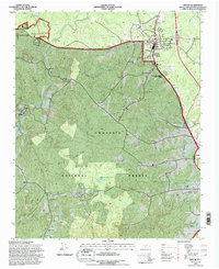 1994 Biscoe1996 Print · USGSBiscoe and the surrounding Uwharrie National Forest are shown in the mid-1990s as the Norfolk Southern railroad linked the region's timber and manufacturing hubs. Researchers can trace family roots at Biscoe Cem and Parsons Grove Ch or locate industrial sites like the Foundry and Lewis Mill Pond.
 - 1994 Map of Candor, 1998 Print
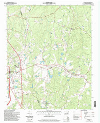 1994 Candor1998 Print · USGSThe rural border of Montgomery and Moore counties comes into focus in the mid-1990s as the regional timber and agricultural economy thrives. Genealogists can trace family landmarks like Flint Hill Church, Big Oak Academy, and Candor Cemetery.
End of results
Showing maps 1-2 of 2
Top cities near Candor
- Pinehurst historical maps
- Seven Lakes historical maps
- Troy historical maps
- Biscoe historical maps
- Robbins historical maps
- Ellerbe historical maps
See more
Frequently asked questions
- What are the different types of historical maps available for Candor?
- What is the oldest map of Candor?
- Where can I purchase historical maps of Candor for my home or office?
- Where can I download high-res historical maps of Candor?
- Are there historical topographic maps available for Candor?
- Is there historical aerial imagery available for Candor?
- Where are historical maps of Candor sourced from?