1970s Maps of New Hanover County, North Carolina
Explore 12 historic maps of New Hanover County from the 1970s. These maps offer a rare glimpse into what life looked like during the 1970s — showing old roads, neighborhoods, homes, and landmarks that have changed or disappeared over time.
Whether you're researching your family's past, planning a metal detecting trip, or studying how New Hanover County's landscape evolved across the 1970s, these high-resolution maps are a powerful tool for exploring the history of this region.
- Focus on a specific era: All maps on this page are from the 1970s, giving you a focused view of this time period.
- See what’s changed: Compare century-old streets, trails, and buildings to today's modern landscape using overlays and satellite layers.
- Research with precision: Use these maps for genealogy, historical research, land use analysis, or educational projects.
- View, download, or print: Maps are fully viewable online in high resolution, and can be downloaded or printed for your own records.
Start exploring New Hanover County's history through authentic maps from the 1970s. This is your window into the past.
New Hanover County, NC maps
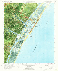
(12)- 1970 Map of Kure Beach, 1972 Print
 1970 Kure Beach1972 Print · USGSThe Lower Cape Fear region in the early seventies shows a landscape defined by military logistics and coastal history. Researchers can trace the layout of the Military Ocean Terminal Sunny Point or locate the Fort Fisher State Historic Site and The Rocks along the river.2 unique versions available
 - 1970 Map of Cape Fear, 1972 Print
 1970 Cape Fear1972 Print · USGSThe North Carolina coast at the dawn of the seventies is preserved in this orthophotomap of the Cape Fear point. Maritime historians and researchers can study the intricate Tidal Flat systems, the historic Bald Head Lighthouse, and the reaching Frying Pan Shoals.
 - 1970 Map of Hampstead, 1972 Print
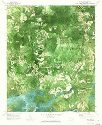
 1970 Hampstead1972 Print · USGSCoastal Pender County at the start of the 1970s reveals a landscape of quiet sounds and growing shoreline communities. Genealogists and local historians can trace the foundations of Hampstead or locate family markers near Topsail Beach and Mallory.2 unique versions available
 - 1970 Map of Wrightsville Beach, 1972 Print
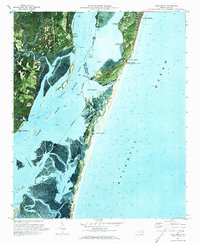
 1970 Wrightsville Beach1972 Print · USGSCoastal New Hanover County comes into focus in the early seventies, showing the development of beach communities and mainland neighborhoods. Researchers can locate the University of North Carolina at Wilmington and trace waterways like Banks Channel and the Intracoastal Waterway.
 - 1970 Map of Carolina Beach, 1973 Print
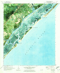
 1970 Carolina Beach1973 Print · USGSThe Cape Fear River and the Atlantic coast meet in this 1970s orthophoto, showing the region during a period of significant military and coastal development. Genealogists and historians can trace family-named sites like Freeman Cem or explore the grounds of Orton Plantation and Snows Cut.2 unique versions available
 - 1970 Map of Scotts Hill, 1973 Print
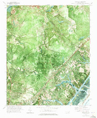 1970 Scotts Hill1973 Print · USGSCoastal New Hanover and Pender Counties appear in the early 1970s as a landscape of tidal creeks and growing mainland settlements. Genealogists can locate family landmarks like Prospect Cem, Oak Grove Ch, and the grounds of Blair Sch.3 unique versions available
 - 1970 Map of Castle Hayne, 1973 Print
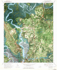 1970 Castle Hayne1973 Print · USGSThe riverfront north of Wilmington comes into focus in the early 1970s as industrial growth meets rural North Carolina. Researchers can trace family roots at Wrightsboro or explore landmarks like St Stanislaus Ch and the New Hanover County Airport.2 unique versions available
 - 1970 Map of Mooretown, 1973 Print
 1970 Mooretown1973 Print · USGSCoastal Pender County is documented here in the early seventies, showing a landscape of deep river swamps and scattered rural industry. Genealogists can locate Ashe Cem and Union Chapel Cem or trace the riverbank near Mooretown.
 - 1970 Map of Rocky Point, 1973 Print
 1970 Rocky Point1973 Print · USGSCoastal Pender County comes into focus in the early 1970s, showing the intersection of river life and rail transport. Researchers can trace family roots through sites like Pender Academy, Rileys Creek Cem, and the settlement at Rocky Point.2 unique versions available
 - 1970 Map of Wilmington, 1973 Print
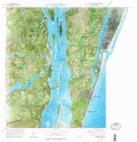
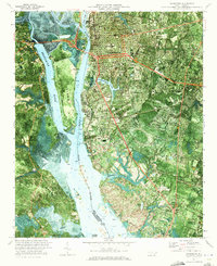 1970 Wilmington1973 Print · USGSWilmington and its busy riverfront appear at a point of significant post-war growth in the early seventies. Trace the industrial footprint of the State Ports Authority, the location of Myrtle Grove, and community hubs like Legion Stadium.3 unique versions available
 - 1972 Map of Beaufort, 1975 Print
 1972 Beaufort1975 Print · USGSThe North Carolina coast in the early seventies shows a landscape defined by massive military bases and coastal sounds. Trace rural family roots at Sarecta and Catherine Lake or explore the barrier islands of the Cape Lookout National Seashore.
 - 1974 Map of Georgetown, 1978 Print
 1974 Georgetown1978 Print · USGSThe Carolina coast and Pee Dee region are shown here in the mid-seventies, just as the Grand Strand was maturing into a premier destination. Researchers can trace the inland rail corridors of the Seaboard Coast Line Railroad or explore the coastal reaches of the Cape Romain National Wildlife Refuge and Myrtle Beach State Park.2 unique versions available
End of results
Showing maps 1-12 of 12
Top cities of New Hanover County
- Wilmington historical maps
- Carolina Beach historical maps
- Wrightsville Beach historical maps
- Kure Beach historical maps
Frequently asked questions
- What are the different types of historical maps available for New Hanover County?
- What is the oldest map of New Hanover County?
- Where can I purchase historical maps of New Hanover County for my home or office?
- Where can I download high-res historical maps of New Hanover County?
- Are there historical topographic maps available for New Hanover County?
- Is there historical aerial imagery available for New Hanover County?
- Where are historical maps of New Hanover County sourced from?