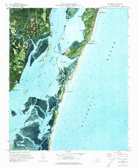
1970 Map of Kure Beach
USGS Topo · Published 1972About this map
Military Ocean Terminal Sunny Point dominates the western bank of the Cape Fear River, highlighting the strategic maritime and military importance of the North Carolina coast in the early 1970s. This orthophotomap provides a unique visual hybrid of traditional topographic data and aerial photography, capturing the complex estuarine environment of Snows Cut and the Intracoastal Waterway. Along the eastern peninsula, the Fort Fisher State Historic Site and the Fort Fisher Air Force Sta stand near Kure Beach, illustrating the overlap of historical preservation and modern defense infrastructure. The shifting geography of the barrier islands is visible through features like Zekes Island and Smith Island, where a network of tidal channels including Muddy Creek, Still Creek, and False Channel weave through the marshland south of New Inlet.
Find a feature on this map
36 named features on this map. Tap any name to fly to it.
Don’t see what you’re looking for? This feature index may not catch every label — zoom into the map to look around manually.
Map Details
Editions of this 1970 Kure Beach Map
2 editions found
Other maps of this area

1942 · Wilmington
USGS Topo · 1:62,500

1942 · Cape Fear
USGS Topo · 1:24,000

1943 · Funston
USGS Topo · 1:24,000

1946 · Southport
USGS Topo · 1:24,000

1946 · Snow Marsh
USGS Topo · 1:24,000

1948 · Wilmington
USGS Topo · 1:62,500

1949 · Georgetown
USGS Topo · 1:250,000

1953 · Florence
USGS Topo · 1:250,000

1953 · Beaufort
USGS Topo · 1:250,000

1954 · Florence
USGS Topo · 1:250,000