1990s Maps of Chapel Hill, North Carolina
Explore 4 historic maps of Chapel Hill from the 1990s. These maps offer a rare glimpse into what life looked like during the 1990s — showing old roads, neighborhoods, homes, and landmarks that have changed or disappeared over time.
Whether you're researching your family's past, planning a metal detecting trip, or studying how Chapel Hill's landscape evolved across the 1990s, these high-resolution maps are a powerful tool for exploring the history of this region.
- Focus on a specific era: All maps on this page are from the 1990s, giving you a focused view of this time period.
- See what’s changed: Compare century-old streets, trails, and buildings to today's modern landscape using overlays and satellite layers.
- Research with precision: Use these maps for genealogy, historical research, land use analysis, or educational projects.
- View, download, or print: Maps are fully viewable online in high resolution, and can be downloaded or printed for your own records.
Start exploring Chapel Hill's history through authentic maps from the 1990s. This is your window into the past.
Chapel Hill, NC maps
(4)- 1990 Map of Raleigh, 1991 Print
 1990 Raleigh1991 Print · USGSGreater Raleigh and the Research Triangle entered a period of significant suburban growth during the 1990s. Researchers can trace the development of towns like Fuquay-Varina and Wake Forest or locate landmarks such as the State Prison and Harris Reservoir.2 unique versions available
 - 1993 Map of Southwest Durham, 1998 Print
 1993 Southwest Durham1998 Print · USGSSouthwestern Durham and the outlying areas of Lowes Grove are captured here in the early nineties as the region's university and research centers continued to expand. Genealogists and local historians can trace the grounds of Maplewood Cemetery, locate the old Whitted Jr High Sch, and follow the shoreline of B Everett Jordan Lake.
 - 1993 Map of Chapel Hill, 1998 Print
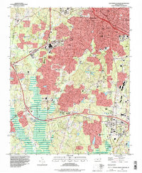
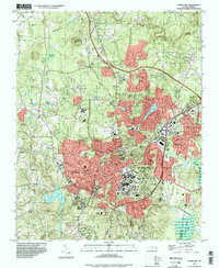 1993 Chapel Hill1998 Print · USGSThe university hub of Chapel Hill and Carrboro is captured here during a period of significant late-century growth. Researchers can trace the development of the University of North Carolina campus, locate family plots in Restland Mem Gardens, and identify landmarks like Iron Mine Hill or Horace Williams Airport.
 - 1993 Map of Farrington, 1999 Print
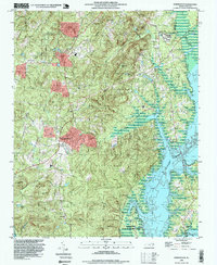 1993 Farrington1999 Print · USGSChatham County during the 1990s shows a landscape transformed by the waters of B. Everett Jordan Lake. Genealogists and local historians can trace family sites like Riggsbee Cemetery and old landmarks like Pritchards Mill Creek and Bells.
End of results
Showing maps 1-4 of 4
Top cities near Chapel Hill
- Raleigh historical maps
- Durham historical maps
- Cary historical maps
- Apex historical maps
- Carrboro historical maps
- Morrisville historical maps
See more
Top neighborhoods of Chapel Hill
- High Park historical maps
- Elkins Hills historical maps
- Estes Hills historical maps
- Colony Park historical maps
- Ashley Forest historical maps
- Carol Woods historical maps
See more
Frequently asked questions
- What are the different types of historical maps available for Chapel Hill?
- What is the oldest map of Chapel Hill?
- Where can I purchase historical maps of Chapel Hill for my home or office?
- Where can I download high-res historical maps of Chapel Hill?
- Are there historical topographic maps available for Chapel Hill?
- Is there historical aerial imagery available for Chapel Hill?
- Where are historical maps of Chapel Hill sourced from?