1940s Maps of Chapel Hill, North Carolina
Explore 3 historic maps of Chapel Hill from the 1940s. These maps offer a rare glimpse into what life looked like during the 1940s — showing old roads, neighborhoods, homes, and landmarks that have changed or disappeared over time.
Whether you're researching your family's past, planning a metal detecting trip, or studying how Chapel Hill's landscape evolved across the 1940s, these high-resolution maps are a powerful tool for exploring the history of this region.
- Focus on a specific era: All maps on this page are from the 1940s, giving you a focused view of this time period.
- See what’s changed: Compare century-old streets, trails, and buildings to today's modern landscape using overlays and satellite layers.
- Research with precision: Use these maps for genealogy, historical research, land use analysis, or educational projects.
- View, download, or print: Maps are fully viewable online in high resolution, and can be downloaded or printed for your own records.
Start exploring Chapel Hill's history through authentic maps from the 1940s. This is your window into the past.
Chapel Hill, NC maps
(3)- 1943 Map of Durham South
 1943 Durham South1943 Print · USGSDurham and its southern reaches are captured here in the early 1940s, showing a tobacco-and-rail landscape at its peak. Genealogists and local historians can trace legacy sites like Beechwood Cem, Lowes Grove, and Roger Grove Ch.2 unique versions available
 - 1946 Map of Chapel Hill, 1958 Print
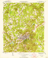 1946 Chapel Hill1958 Print · USGSMid-century Chapel Hill and Carrboro emerge from the post-war era as significant academic and transit hubs. Researchers can trace the layout of early neighborhoods, local family burials at Cheek Cem, and rural sites like Mason Farm or Horace Williams Airport.2 unique versions available
 - 1947 Map of Chapel Hill
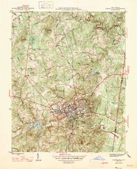 1947 Chapel Hill1947 Print · USGSPost-war North Carolina comes into focus through this survey of Chapel Hill and Carrboro. Genealogists and historians can trace family roots through landmarks like Morris Grove Sch, Partin Cem, and the rural settlement at Blackwood.2 unique versions available
End of results
Showing maps 1-3 of 3
Top cities near Chapel Hill
- Raleigh historical maps
- Durham historical maps
- Cary historical maps
- Apex historical maps
- Carrboro historical maps
- Morrisville historical maps
See more
Top neighborhoods of Chapel Hill
- High Park historical maps
- Elkins Hills historical maps
- Estes Hills historical maps
- Colony Park historical maps
- Ashley Forest historical maps
- Carol Woods historical maps
See more
Frequently asked questions
- What are the different types of historical maps available for Chapel Hill?
- What is the oldest map of Chapel Hill?
- Where can I purchase historical maps of Chapel Hill for my home or office?
- Where can I download high-res historical maps of Chapel Hill?
- Are there historical topographic maps available for Chapel Hill?
- Is there historical aerial imagery available for Chapel Hill?
- Where are historical maps of Chapel Hill sourced from?