1940s Maps of Pamlico County, North Carolina
Explore 5 historic maps of Pamlico County from the 1940s. These maps offer a rare glimpse into what life looked like during the 1940s — showing old roads, neighborhoods, homes, and landmarks that have changed or disappeared over time.
Whether you're researching your family's past, planning a metal detecting trip, or studying how Pamlico County's landscape evolved across the 1940s, these high-resolution maps are a powerful tool for exploring the history of this region.
- Focus on a specific era: All maps on this page are from the 1940s, giving you a focused view of this time period.
- See what’s changed: Compare century-old streets, trails, and buildings to today's modern landscape using overlays and satellite layers.
- Research with precision: Use these maps for genealogy, historical research, land use analysis, or educational projects.
- View, download, or print: Maps are fully viewable online in high resolution, and can be downloaded or printed for your own records.
Start exploring Pamlico County's history through authentic maps from the 1940s. This is your window into the past.
Pamlico County, NC maps
(5)- 1948 Map of Oriental, 1992 Print
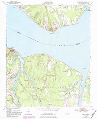
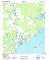 1948 Oriental1992 Print · USGSThe coastal waters of Pamlico County meet the riverfront during the post-war era, showing the maritime heart of the region. Local historians can trace the growth of Oriental and locate rural landmarks like Pilgrim Chapel, Whortonsville, and Bethel Ch.
 - 1949 Map of Havelock, 1952 Print
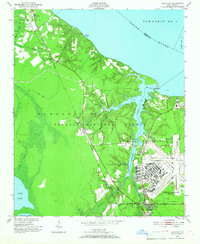 1949 Havelock1952 Print · USGSCoastal North Carolina at the dawn of the fifties shows a landscape of deep pine forests and growing military infrastructure. Researchers can trace the early layout of the Cherry Point Air Station and locate local landmarks like Brice Creek Ch and the Croatan Lookout Tower.4 unique versions available
 - 1949 Map of Point Of Marsh, 1976 Print
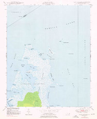 1949 Point Of Marsh1976 Print · USGSThe coastal marshes of Carteret County are documented here in the late 1940s, showing the meeting of the Neuse River and Pamlico Sound. Maritime researchers can trace the shoreline of Piney Island and locate remote navigation aids like Point of Marsh Lt and Cedar Island Bay Lt.3 unique versions available
 - 1949 Map of Merrimon, 1983 Print
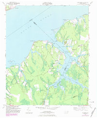 1949 Merrimon1983 Print · USGSCoastal life in mid-century North Carolina centered on the intricate waterways of the Neuse River and the Intracoastal route. Genealogists can trace family footprints through rural landmarks like Reels Chapel, Oak Grove Ch, and the Adams Creek Sch.
 - 1949 Map of Cherry Point, 1984 Print
 1949 Cherry Point1984 Print · USGSThe Neuse River shoreline just after World War II shows a landscape defined by the arrival of the Cherry Point Marine Base and the depth of the Croatan National Forest. Genealogists and local historians can trace rural landmarks like Weeping Mary Ch, Cahoogue Creek Sch, and the riverside Minnesott Beach.
End of results
Showing maps 1-5 of 5
Top cities of Pamlico County
- Bayboro historical maps
- Oriental historical maps
- Alliance historical maps
- Grantsboro historical maps
- Minnesott Beach historical maps
- Arapahoe historical maps
See more
Frequently asked questions
- What are the different types of historical maps available for Pamlico County?
- What is the oldest map of Pamlico County?
- Where can I purchase historical maps of Pamlico County for my home or office?
- Where can I download high-res historical maps of Pamlico County?
- Are there historical topographic maps available for Pamlico County?
- Is there historical aerial imagery available for Pamlico County?
- Where are historical maps of Pamlico County sourced from?