1980s Maps of Ivy Trace, Pasquotank County
Explore 3 historic maps of Ivy Trace from the 1980s. These maps offer a rare glimpse into what life looked like during the 1980s — showing old roads, neighborhoods, homes, and landmarks that have changed or disappeared over time.
Whether you're researching your family's past, planning a metal detecting trip, or studying how Ivy Trace's landscape evolved across the 1980s, these high-resolution maps are a powerful tool for exploring the history of this region.
- Focus on a specific era: All maps on this page are from the 1980s, giving you a focused view of this time period.
- See what’s changed: Compare century-old streets, trails, and buildings to today's modern landscape using overlays and satellite layers.
- Research with precision: Use these maps for genealogy, historical research, land use analysis, or educational projects.
- View, download, or print: Maps are fully viewable online in high resolution, and can be downloaded or printed for your own records.
Start exploring Ivy Trace's history through authentic maps from the 1980s. This is your window into the past.
Ivy Trace, Pasquotank County maps
(3)- 1982 Map of Weeksville
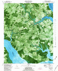 1982 Weeksville1982 Print · USGSCoastal Pasquotank County is seen here in the early eighties as a landscape of tidewater creeks and established rural communities. Trace the grounds of the USCG Airbase or locate local landmarks like Newbegun Ch and Listers Corner near the Albemarle Sound.
 - 1982 Map of Elizabeth City, 1983 Print
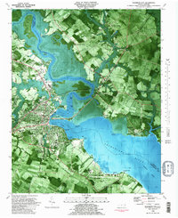 1982 Elizabeth City1983 Print · USGSElizabeth City and its surroundings are captured in the early 1980s during a period of steady growth along the Pasquotank River. Genealogists and historians can trace the foundations of Elizabeth City State University, the U S Coast Guard Air Base, and community landmarks like Sawyers Creek Ch.2 unique versions available
 - 1985 Map of Elizabeth City
 1985 Elizabeth City1985 Print · USGSCoastal North Carolina's rivers and sounds define the landscape of the mid-eighties, from the vast swamps to the historical waterfronts of Elizabeth City and Edenton. Researchers can trace the rail lines of the Southern Ry or locate landmarks like Beaver Hill Cem and South Mills.2 unique versions available
End of results
Showing maps 1-3 of 3
Frequently asked questions
- What are the different types of historical maps available for Ivy Trace?
- What is the oldest map of Ivy Trace?
- Where can I purchase historical maps of Ivy Trace for my home or office?
- Where can I download high-res historical maps of Ivy Trace?
- Are there historical topographic maps available for Ivy Trace?
- Is there historical aerial imagery available for Ivy Trace?
- Where are historical maps of Ivy Trace sourced from?