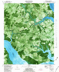
1982 Map of Weeksville
USGS Topo · Published 1982About this map
Newbegun Creek winds through the heart of this coastal landscape, defining the rural character of southeastern Pasquotank County during the early 1980s. The settlement of Weeksville serves as a central hub, surrounded by a dense network of country churches including Newbegun Ch, Rebecca Ch, and Galilee Ch. This orthophotomap, derived from 1977 aerial photography, reveals the intricate relationship between the land and the surrounding waters of the Pasquotank River and Albemarle Sound.
Find a feature on this map
34 named features on this map. Tap any name to fly to it.
Don’t see what you’re looking for? This feature index may not catch every label — zoom into the map to look around manually.
Map Details
Editions of this 1982 Weeksville Map
This is the sole edition of this map. No revisions or reprints were ever made.
Other maps of this area

1906 · Hertford
USGS Topo · 1:62,500

1940 · Hertford
USGS Topo · 1:62,500

1940 · Wade Point
USGS Topo · 1:62,500

1940 · South Mills
USGS Topo · 1:62,500

1943 · Wade Point
USGS Topo · 1:62,500

1948 · Wade Point
USGS Topo · 1:62,500

1948 · Elizabeth City
USGS Topo · 1:62,500

1952 · South Mills
USGS Topo · 1:62,500

1953 · Norfolk
USGS Topo · 1:250,000

1982 · Nixonton
USGS Topo · 1:24,000