1980s Maps of Caltolina, North Carolina
Explore 2 historic maps of Caltolina from the 1980s. These maps offer a rare glimpse into what life looked like during the 1980s — showing old roads, neighborhoods, homes, and landmarks that have changed or disappeared over time.
Whether you're researching your family's past, planning a metal detecting trip, or studying how Caltolina's landscape evolved across the 1980s, these high-resolution maps are a powerful tool for exploring the history of this region.
- Focus on a specific era: All maps on this page are from the 1980s, giving you a focused view of this time period.
- See what’s changed: Compare century-old streets, trails, and buildings to today's modern landscape using overlays and satellite layers.
- Research with precision: Use these maps for genealogy, historical research, land use analysis, or educational projects.
- View, download, or print: Maps are fully viewable online in high resolution, and can be downloaded or printed for your own records.
Start exploring Caltolina's history through authentic maps from the 1980s. This is your window into the past.
Caltolina, NC maps
(2)- 1980 Map of Triple Springs, 1981 Print
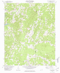 1980 Triple Springs1981 Print · USGSNorth Carolina’s Piedmont borderlands are shown here in the late seventies, just after the creation of the reservoir. Researchers can trace rural life through the locations of Denny Store, the Olive Branch Ch, and the waters of Mayo Reservoir.
 - 1984 Map of Henderson, 1985 Print
 1984 Henderson1985 Print · USGSNorth Carolina’s northern Piedmont comes into focus in the mid-1980s, centered on the crossroads of Henderson and Oxford. Genealogists and historians can trace the paths of the Southern railroad or locate communities near the Camp Butner National Guard Range and John H. Kerr Reservoir.
End of results
Showing maps 1-2 of 2
Top cities near Caltolina
- Roxboro historical maps
- Oxford historical maps
- Butner historical maps
- Stem historical maps
- Virgilina historical maps
Frequently asked questions
- What are the different types of historical maps available for Caltolina?
- What is the oldest map of Caltolina?
- Where can I purchase historical maps of Caltolina for my home or office?
- Where can I download high-res historical maps of Caltolina?
- Are there historical topographic maps available for Caltolina?
- Is there historical aerial imagery available for Caltolina?
- Where are historical maps of Caltolina sourced from?