1990s Maps of Greenville, North Carolina
Explore 4 historic maps of Greenville from the 1990s. These maps offer a rare glimpse into what life looked like during the 1990s — showing old roads, neighborhoods, homes, and landmarks that have changed or disappeared over time.
Whether you're researching your family's past, planning a metal detecting trip, or studying how Greenville's landscape evolved across the 1990s, these high-resolution maps are a powerful tool for exploring the history of this region.
- Focus on a specific era: All maps on this page are from the 1990s, giving you a focused view of this time period.
- See what’s changed: Compare century-old streets, trails, and buildings to today's modern landscape using overlays and satellite layers.
- Research with precision: Use these maps for genealogy, historical research, land use analysis, or educational projects.
- View, download, or print: Maps are fully viewable online in high resolution, and can be downloaded or printed for your own records.
Start exploring Greenville's history through authentic maps from the 1990s. This is your window into the past.
Greenville, NC maps
(4)- 1998 Map of Greenville SE, 2001 Print
 1998 Greenville SE2001 Print · USGSSoutheast of Greenville in the late 1990s, the growing campus of East Carolina University meets the rural crossroads of Pitt County. Genealogists and historians can trace numerous rural cemeteries and small communities like Hollywood Crossroads, Simpson, and Galloway Crossroads.
 - 1998 Map of Greenville SW, 2001 Print
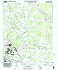
 1998 Greenville SW2001 Print · USGSPitt County's growth is captured here in the late nineties as Greenville expands south toward Winterville. Genealogists and local historians can locate specific community landmarks like Red Oak Ch, Sadie Saulter Sch, and the rural junction at Hines Crossroads.
 - 1998 Map of Greenville NE, 2001 Print
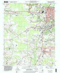
 1998 Greenville NE2001 Print · USGSGreenville and its rural northern outskirts are captured in the late nineties as urban growth began pressing into the surrounding farmland. Genealogists and local historians can locate many rural landmarks, from Sweet Gum Grove Ch to the County Fairground.
 - 1998 Map of Greenville NW, 2001 Print
 1998 Greenville NW2001 Print · USGSNorthwest of Greenville in the late nineties, the Tar River bottomlands reveal a landscape of rural crossroads and wetlands. Genealogists can trace family landmarks like Belvoir Sch, Gum Swamp Ch, and the landing at Center Bluff.
End of results
Showing maps 1-4 of 4
Top cities near Greenville
- Ayden historical maps
- Winterville historical maps
- Farmville historical maps
- Bethel historical maps
- Robersonville historical maps
- Hookerton historical maps
See more
Top neighborhoods of Greenville
- Bell Fork historical maps
- Oakmont historical maps
- Brook Valley historical maps
- Paramore Farm historical maps
- Drexelbrook historical maps
- Eastwood historical maps
See more
Frequently asked questions
- What are the different types of historical maps available for Greenville?
- What is the oldest map of Greenville?
- Where can I purchase historical maps of Greenville for my home or office?
- Where can I download high-res historical maps of Greenville?
- Are there historical topographic maps available for Greenville?
- Is there historical aerial imagery available for Greenville?
- Where are historical maps of Greenville sourced from?