1900s (20th Century) Maps of Staton, North Carolina
Explore 7 historic maps of Staton from the 1900s (20th Century). These maps offer a rare glimpse into what life looked like during the 1900s — showing old roads, neighborhoods, homes, and landmarks that have changed or disappeared over time.
Whether you're researching your family's past, planning a metal detecting trip, or studying how Staton's landscape evolved across the 1900s, these high-resolution maps are a powerful tool for exploring the history of this region.
- Focus on a specific era: All maps on this page are from the 1900s, giving you a focused view of this time period.
- See what’s changed: Compare century-old streets, trails, and buildings to today's modern landscape using overlays and satellite layers.
- Research with precision: Use these maps for genealogy, historical research, land use analysis, or educational projects.
- View, download, or print: Maps are fully viewable online in high resolution, and can be downloaded or printed for your own records.
Start exploring Staton's history through authentic maps from the 1900s. This is your window into the past.
Staton, NC maps
(7)- 1903 Map of Winterville, 1954 Print
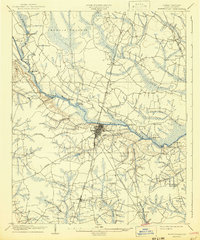
 1903 Winterville1954 Print · USGSPitt County at the dawn of the twentieth century was a landscape of river landings and new rail lines. Genealogists can trace early homesteads near Greenville and Winterville or locate landmarks like the Pitt County Poor Farm and Browns Old Ferry.
 - 1905 Map of Winterville, 1942 Print
 1905 Winterville1942 Print · USGSPitt County at the dawn of the twentieth century was a landscape shaped by the Tar River and the expanding A. C. L. R. R. network. Genealogists and local historians can trace family-named sites like Galloway Crossroads, identify the location of the Pitt County Poor Farm, or locate vanished river landings such as Pillsboro Ldg.
 - 1953 Map of Rocky Mount, 1964 Print
 1953 Rocky Mount1964 Print · USGSEastern North Carolina in the mid-fifties is defined by its deep river basins and the vast wetlands of the Tidewater. Genealogists can trace family roots through hubs like Kinston and New Bern or explore the wilderness of Pettigrew State Park and Lake Mattamuskeet.4 unique versions available
 - 1954 Map of Rocky Mount
 1954 Rocky Mount1954 Print · USGSEastern North Carolina is mapped in the mid-fifties, showing a landscape of sounds, swamps, and steam-era rail lines. Genealogists can trace the rural road networks and rail spurs connecting towns like Tarboro, Greenville, and the remote Columbia.
 - 1981 Map of Greenville NE, 1982 Print
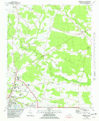 1981 Greenville NE1982 Print · USGSPitt County's agricultural landscape and rural church communities are captured here in the early eighties. Genealogists and local historians can trace family landmarks and rural centers like Stokes, Sycamore Chapel, and the North Pitt High Sch.
 - 1985 Map of Rocky Mount
 1985 Rocky Mount1985 Print · USGSThe eastern North Carolina coastal plain in the mid-eighties shows a landscape defined by its river-and-rail heritage. Genealogists and local historians can trace the development of Rocky Mount, Greenville, and Wilson, or locate landmarks like East Carolina University and the Voice of America site.2 unique versions available
 - 1998 Map of Greenville NE, 2001 Print
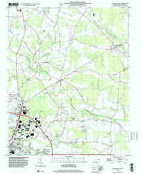 1998 Greenville NE2001 Print · USGSGreenville and its rural northern outskirts are captured in the late nineties as urban growth began pressing into the surrounding farmland. Genealogists and local historians can locate many rural landmarks, from Sweet Gum Grove Ch to the County Fairground.
End of results
Showing maps 1-7 of 7
Top cities near Staton
- Greenville historical maps
- Tarboro historical maps
- Ayden historical maps
- Winterville historical maps
- Farmville historical maps
- Bethel historical maps
See more
Frequently asked questions
- What are the different types of historical maps available for Staton?
- What is the oldest map of Staton?
- Where can I purchase historical maps of Staton for my home or office?
- Where can I download high-res historical maps of Staton?
- Are there historical topographic maps available for Staton?
- Is there historical aerial imagery available for Staton?
- Where are historical maps of Staton sourced from?