1970s Maps of Trinity, North Carolina
Explore 3 historic maps of Trinity from the 1970s. These maps offer a rare glimpse into what life looked like during the 1970s — showing old roads, neighborhoods, homes, and landmarks that have changed or disappeared over time.
Whether you're researching your family's past, planning a metal detecting trip, or studying how Trinity's landscape evolved across the 1970s, these high-resolution maps are a powerful tool for exploring the history of this region.
- Focus on a specific era: All maps on this page are from the 1970s, giving you a focused view of this time period.
- See what’s changed: Compare century-old streets, trails, and buildings to today's modern landscape using overlays and satellite layers.
- Research with precision: Use these maps for genealogy, historical research, land use analysis, or educational projects.
- View, download, or print: Maps are fully viewable online in high resolution, and can be downloaded or printed for your own records.
Start exploring Trinity's history through authentic maps from the 1970s. This is your window into the past.
Trinity, NC maps
(3)- 1970 Map of Glenola, 1973 Print
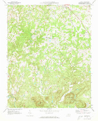 1970 Glenola1973 Print · USGSRandolph County's rural landscape is depicted here in the early seventies, showing a network of small crossroad communities and mountain ridges. Genealogists can locate family landmarks like Poplar Ridge Ch, Glenola, and the Covered Bridge over the Little Uwharrie River.2 unique versions available
 - 1977 Map of Fair Grove, 1979 Print
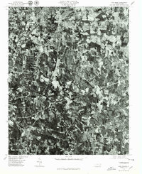 1977 Fair Grove1979 Print · USGSThe Davidson County landscape appears in sharp photographic detail during the late seventies, showing the growth of the Piedmont triad. Researchers can trace land use and homestead locations near Fair Grove, Glen Anna, and along the Little Uwharrie River.
 - 1977 Map of High Point West, 1979 Print
 1977 High Point West1979 Print · USGSThe Piedmont's industrial heart comes into focus in the late 1970s, showcasing the urban expansion between High Point and Thomasville. Researchers can trace old property lines and the early residential footprint of Oakview near the banks of Abbotts Creek.
End of results
Showing maps 1-3 of 3
Top cities near Trinity
- Greensboro historical maps
- Winston-Salem historical maps
- High Point historical maps
- Thomasville historical maps
- Asheboro historical maps
- Kernersville historical maps
See more
Top neighborhoods of Trinity
- Colonial Heights historical maps
- Stone Gables historical maps
- Steeplegate historical maps
- Trinity Townes historical maps
- Stones Throw historical maps
- Cottages at Piper Village historical maps
See more
Frequently asked questions
- What are the different types of historical maps available for Trinity?
- What is the oldest map of Trinity?
- Where can I purchase historical maps of Trinity for my home or office?
- Where can I download high-res historical maps of Trinity?
- Are there historical topographic maps available for Trinity?
- Is there historical aerial imagery available for Trinity?
- Where are historical maps of Trinity sourced from?