1970s Maps of Albemarle, North Carolina
Explore 2 historic maps of Albemarle from the 1970s. These maps offer a rare glimpse into what life looked like during the 1970s — showing old roads, neighborhoods, homes, and landmarks that have changed or disappeared over time.
Whether you're researching your family's past, planning a metal detecting trip, or studying how Albemarle's landscape evolved across the 1970s, these high-resolution maps are a powerful tool for exploring the history of this region.
- Focus on a specific era: All maps on this page are from the 1970s, giving you a focused view of this time period.
- See what’s changed: Compare century-old streets, trails, and buildings to today's modern landscape using overlays and satellite layers.
- Research with precision: Use these maps for genealogy, historical research, land use analysis, or educational projects.
- View, download, or print: Maps are fully viewable online in high resolution, and can be downloaded or printed for your own records.
Start exploring Albemarle's history through authentic maps from the 1970s. This is your window into the past.
Albemarle, NC maps
(2)- 1977 Map of Albemarle SW, 1979 Print
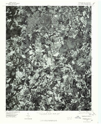 1977 Albemarle SW1979 Print · USGSThe outskirts of Albemarle in the late seventies show a landscape of growing urban borders and rural homesteads. Local researchers can trace the development of Albemarle, the small settlement at Porter, and the path of Long Creek.
 - 1977 Map of Albemarle NW, 1979 Print
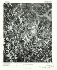 1977 Albemarle NW1979 Print · USGSStanly County in the late seventies is shown in remarkable aerial detail, reflecting the transition between rural agriculture and town growth. Trace old property lines and community landmarks like Austins Mill, New London, and the shores of Badin Lake.
End of results
Showing maps 1-2 of 2
Top cities near Albemarle
- Norwood historical maps
- Rockwell historical maps
- Stanfield historical maps
- Mount Pleasant historical maps
- Mount Gilead historical maps
- Badin historical maps
See more
Top neighborhoods of Albemarle
- Heathwood historical maps
- North Springhaven historical maps
- Ashley Heights historical maps
- Bethney Heights historical maps
- Cedar Knolls historical maps
- Greenwood Park historical maps
See more
Frequently asked questions
- What are the different types of historical maps available for Albemarle?
- What is the oldest map of Albemarle?
- Where can I purchase historical maps of Albemarle for my home or office?
- Where can I download high-res historical maps of Albemarle?
- Are there historical topographic maps available for Albemarle?
- Is there historical aerial imagery available for Albemarle?
- Where are historical maps of Albemarle sourced from?