1980s Maps of Albemarle, North Carolina
Explore 4 historic maps of Albemarle from the 1980s. These maps offer a rare glimpse into what life looked like during the 1980s — showing old roads, neighborhoods, homes, and landmarks that have changed or disappeared over time.
Whether you're researching your family's past, planning a metal detecting trip, or studying how Albemarle's landscape evolved across the 1980s, these high-resolution maps are a powerful tool for exploring the history of this region.
- Focus on a specific era: All maps on this page are from the 1980s, giving you a focused view of this time period.
- See what’s changed: Compare century-old streets, trails, and buildings to today's modern landscape using overlays and satellite layers.
- Research with precision: Use these maps for genealogy, historical research, land use analysis, or educational projects.
- View, download, or print: Maps are fully viewable online in high resolution, and can be downloaded or printed for your own records.
Start exploring Albemarle's history through authentic maps from the 1980s. This is your window into the past.
Albemarle, NC maps
(4)- 1980 Map of New London
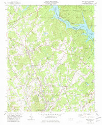 1980 New London1980 Print · USGSStanly County life in the late seventies centers on the industrial and rail corridors between New London and the Yadkin River. Researchers can trace old family sites and rural landmarks like Parker Memorial Ch, Halls Ferry Jct, and the Claypits near Isenhour.2 unique versions available
 - 1981 Map of Frog Pond
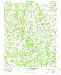 1981 Frog Pond1981 Print · USGSStanly County community life in the late seventies is captured here through its dense network of rural churches and family settlements. Genealogists can trace family roots through landmarks like St Martin, Ridgecrest Cem, and the old Ridgecrest Sch.2 unique versions available
 - 1981 Map of Albemarle, 1982 Print
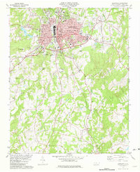 1981 Albemarle1982 Print · USGSAlbemarle is shown as a bustling county seat in the early eighties, where the rail lines and textile history meet the rolling Piedmont. Genealogists can trace family names at Stanly Gardens Cem or visit rural landmarks like Bethesda Ch and Porter.
 - 1985 Map of Charlotte, 1986 Print
 1985 Charlotte1986 Print · USGSThe Piedmont region in the mid-eighties shows the rapid growth of the Charlotte metro area alongside established textile and college towns. Trace local heritage at the Reed Gold Mine or explore the rail corridors of the Southern Railway and Winston-Salem Southbound Railway.2 unique versions available
End of results
Showing maps 1-4 of 4
Top cities near Albemarle
- Norwood historical maps
- Rockwell historical maps
- Stanfield historical maps
- Mount Pleasant historical maps
- Mount Gilead historical maps
- Badin historical maps
See more
Top neighborhoods of Albemarle
- Heathwood historical maps
- North Springhaven historical maps
- Ashley Heights historical maps
- Bethney Heights historical maps
- Cedar Knolls historical maps
- Greenwood Park historical maps
See more
Frequently asked questions
- What are the different types of historical maps available for Albemarle?
- What is the oldest map of Albemarle?
- Where can I purchase historical maps of Albemarle for my home or office?
- Where can I download high-res historical maps of Albemarle?
- Are there historical topographic maps available for Albemarle?
- Is there historical aerial imagery available for Albemarle?
- Where are historical maps of Albemarle sourced from?