1970s Maps of Dobson, North Carolina
Explore 3 historic maps of Dobson from the 1970s. These maps offer a rare glimpse into what life looked like during the 1970s — showing old roads, neighborhoods, homes, and landmarks that have changed or disappeared over time.
Whether you're researching your family's past, planning a metal detecting trip, or studying how Dobson's landscape evolved across the 1970s, these high-resolution maps are a powerful tool for exploring the history of this region.
- Focus on a specific era: All maps on this page are from the 1970s, giving you a focused view of this time period.
- See what’s changed: Compare century-old streets, trails, and buildings to today's modern landscape using overlays and satellite layers.
- Research with precision: Use these maps for genealogy, historical research, land use analysis, or educational projects.
- View, download, or print: Maps are fully viewable online in high resolution, and can be downloaded or printed for your own records.
Start exploring Dobson's history through authentic maps from the 1970s. This is your window into the past.
Dobson, NC maps
(3)- 1971 Map of Dobson, 1973 Print
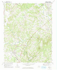 1971 Dobson1973 Print · USGSThe county seat of Dobson is captured in the early seventies alongside emerging institutions and rural crossroads. Genealogists can trace family landmarks like Emmanuel Ch, Franklin Sch, and the riverside settlement of New Hope.3 unique versions available
 - 1971 Map of Bottom, 1973 Print
 1971 Bottom1973 Print · USGSSurry County in the early seventies was a land of steep knobs and river valleys where community life revolved around local landmarks. Trace family history at Salem Fork Cem, locate Blevins Store, or find the old Beulah Sch.3 unique versions available
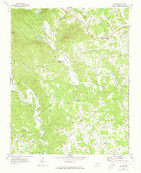
 - 1976 Map of Dobson, 1979 Print
 1976 Dobson1979 Print · USGSSurry County at the Bicentennial is captured in this aerial-based survey, showing the rural landscape around the town of Dobson. Local historians can trace exact land use and homestead locations near White Plains, Toast, and Turkey Ford.
End of results
Showing maps 1-3 of 3
Top cities near Dobson
- Mount Airy historical maps
- Jonesville historical maps
- Cana historical maps
- Boonville historical maps
- East Bend historical maps
- Ronda historical maps
Frequently asked questions
- What are the different types of historical maps available for Dobson?
- What is the oldest map of Dobson?
- Where can I purchase historical maps of Dobson for my home or office?
- Where can I download high-res historical maps of Dobson?
- Are there historical topographic maps available for Dobson?
- Is there historical aerial imagery available for Dobson?
- Where are historical maps of Dobson sourced from?