1970s Maps of Swain County, North Carolina
Explore 12 historic maps of Swain County from the 1970s. These maps offer a rare glimpse into what life looked like during the 1970s — showing old roads, neighborhoods, homes, and landmarks that have changed or disappeared over time.
Whether you're researching your family's past, planning a metal detecting trip, or studying how Swain County's landscape evolved across the 1970s, these high-resolution maps are a powerful tool for exploring the history of this region.
- Focus on a specific era: All maps on this page are from the 1970s, giving you a focused view of this time period.
- See what’s changed: Compare century-old streets, trails, and buildings to today's modern landscape using overlays and satellite layers.
- Research with precision: Use these maps for genealogy, historical research, land use analysis, or educational projects.
- View, download, or print: Maps are fully viewable online in high resolution, and can be downloaded or printed for your own records.
Start exploring Swain County's history through authentic maps from the 1970s. This is your window into the past.
Swain County, NC maps
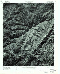
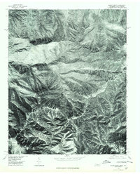
(12)- 1976 Map of Wesser
 1976 Wesser1976 Print · USGSWestern North Carolina's river valleys and high ridges are captured in this mid-seventies aerial survey. Researchers can trace the development of mountain hamlets like Wesser and Almond near the waters of Fontana Lake.
 - 1976 Map of Hewitt, 1978 Print
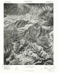
 1976 Hewitt1978 Print · USGSThe southern Appalachians of Western North Carolina are captured here in the mid-seventies, showing the deep river gorges and mountain settlements. Researchers can trace land patterns along the Nantahala River and locate small communities like Hewitt and Beechertown.
 - 1976 Map of Silers Bald, 1978 Print
 1976 Silers Bald1978 Print · USGSHigh-elevation peaks and dense mountain forests dominate the North Carolina borderlands in the mid-seventies. Researchers can trace the rugged intersection of massive spurs like Goshen Ridge, Welch Ridge, and the prominent peak at Silers Bald.
 - 1976 Map of Clingmans Dome, 1978 Print
 1976 Clingmans Dome1978 Print · USGSThe high peaks of the Great Smoky Mountains are captured in the mid-seventies through this detailed aerial orthophotograph. Researchers can trace the sharp descent from Clingmans Dome along the prominent Noland Divide and Fork Ridge.
 - 1976 Map of Noland Creek, 1978 Print
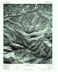
 1976 Noland Creek1978 Print · USGSSwain County in the mid-1970s is defined by the expansive, winding waters of Fontana Lake as it snakes through the mountain terrain. Researchers can trace the original river paths of the Tuckasegee River and find landmarks like Roundhill.
 - 1976 Map of Bunches Bald, 1978 Print
 1976 Bunches Bald1978 Print · USGSThe high ridges of Swain County are captured in the mid-seventies through detailed aerial photography. Hikers and local historians can trace the steep drainages of Raven Fork and identify prominent peaks like Bunches Bald and Barnett Knob.
 - 1976 Map of Mount Le Conte, 1978 Print
 1976 Mount Le Conte1978 Print · USGSThe Tennessee and North Carolina borderlands come into sharp focus in this mid-1970s aerial survey. Trace the early footprint of Gatlinburg and find the forested slopes of Mount Le Conte and the State Line Divide.
 - 1976 Map of Tuskeegee, 1978 Print
 1976 Tuskeegee1978 Print · USGSThe mountain community of Tuskeegee and the deep waters of Fontana Lake are captured in high detail during the 1970s. Trace the winding shoreline of the Little Tennessee River and the heights of Welch Ridge.
 - 1976 Map of Fontana Dam, 1978 Print
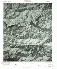 1976 Fontana Dam1978 Print · USGSGraham County and the southern Appalachian landscape are captured in this mid-seventies aerial survey just south of the Great Smoky Mountains. Researchers can trace the layout of Fontana Village and the massive infrastructure of Fontana Dam along the Little Tennessee River.
 - 1976 Map of Bryson City, 1978 Print
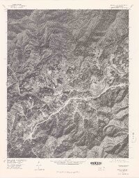 1976 Bryson City1978 Print · USGSBryson City and the banks of the Tuckasegee River are captured in this mid-seventies aerial survey. Local historians and property researchers can trace the roads around Bryson City, the settlement at Ela, and the eastern finger of Fontana Lake.
 - 1976 Map of Mount Guyot, 1979 Print
 1976 Mount Guyot1979 Print · USGSHigh in the Great Smoky Mountains during the mid-1970s, this aerial orthophoto captures the wilderness border between Tennessee and North Carolina. Trace the ridgelines from Mount Guyot to Tricorner Knob and the rugged descent of the Raven Fork.
 - 1976 Map of Luftee Knob, 1979 Print
 1976 Luftee Knob1979 Print · USGSThe high peaks of the Smokies are captured in this mid-seventies orthophotoquad, showing the dense timber and deep drainages of Haywood County. Researchers can trace the elevation changes and land cover from Luftee Knob across to Big Cataloochee Mountain.
End of results
Showing maps 1-12 of 12
Top cities of Swain County
Frequently asked questions
- What are the different types of historical maps available for Swain County?
- What is the oldest map of Swain County?
- Where can I purchase historical maps of Swain County for my home or office?
- Where can I download high-res historical maps of Swain County?
- Are there historical topographic maps available for Swain County?
- Is there historical aerial imagery available for Swain County?
- Where are historical maps of Swain County sourced from?