1940s Maps of Indian Lake Estates, North Carolina
Explore 2 historic maps of Indian Lake Estates from the 1940s. These maps offer a rare glimpse into what life looked like during the 1940s — showing old roads, neighborhoods, homes, and landmarks that have changed or disappeared over time.
Whether you're researching your family's past, planning a metal detecting trip, or studying how Indian Lake Estates's landscape evolved across the 1940s, these high-resolution maps are a powerful tool for exploring the history of this region.
- Focus on a specific era: All maps on this page are from the 1940s, giving you a focused view of this time period.
- See what’s changed: Compare century-old streets, trails, and buildings to today's modern landscape using overlays and satellite layers.
- Research with precision: Use these maps for genealogy, historical research, land use analysis, or educational projects.
- View, download, or print: Maps are fully viewable online in high resolution, and can be downloaded or printed for your own records.
Start exploring Indian Lake Estates's history through authentic maps from the 1940s. This is your window into the past.
Indian Lake Estates, NC maps
(2)- 1946 Map of Lake Toxaway, 1956 Print
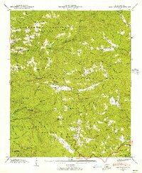 1946 Lake Toxaway1956 Print · USGSTransylvania and Jackson counties are captured in the late 1940s, highlighting the mountainous terrain of the Nantahala National Forest and Pisgah National Forest. Researchers can locate family landmarks like the Mc Call Cem, Tennessee Gap Sch, and the community at Quebec.4 unique versions available
 - 1947 Map of Lake Toxaway
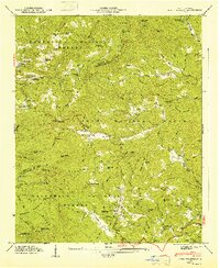 1947 Lake Toxaway1947 Print · USGSTransylvania and Jackson counties are captured just after the war when mountain life revolved around isolated schools and churches. Genealogists can locate family landmarks like the McCall Cem, Tennessee Gap Sch, and the community of Quebec.
End of results
Showing maps 1-2 of 2
Top cities near Indian Lake Estates
Frequently asked questions
- What are the different types of historical maps available for Indian Lake Estates?
- What is the oldest map of Indian Lake Estates?
- Where can I purchase historical maps of Indian Lake Estates for my home or office?
- Where can I download high-res historical maps of Indian Lake Estates?
- Are there historical topographic maps available for Indian Lake Estates?
- Is there historical aerial imagery available for Indian Lake Estates?
- Where are historical maps of Indian Lake Estates sourced from?