1946 Map of Lake Toxaway
USGS Topo · Published 1956About this map
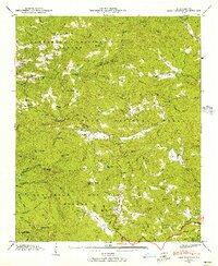
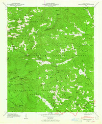
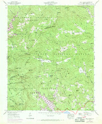
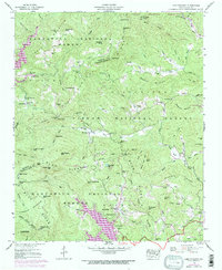
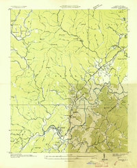
Lake Toxaway and the surrounding high country of the Blue Ridge dominate this mid-century survey, showcasing a landscape defined by the drainage of the French Broad River and Toxaway River. The terrain is divided between the Nantahala National Forest and Pisgah National Forest, where steep ridges like Hogback Mountain and Big Pisgah Mtn tower over small mountain communities. Settled areas like Quebec and Cashiers are connected by winding mountain roads, including State Route 281, which passes near several remote educational and religious centers. Notable local landmarks include the Toxaway Mtn lookout tower and several mountain-top features like The Pinnacle and Sassafras Knob. The presence of institutions such as Tennessee Gap Sch, Silverstein Sch, and Big Pisgah Ch reflects the rural social structure of the era, while the numerous cemeteries like Owens Cem and Mc Call Cem offer specific geographic data for genealogists tracing families in these mountain gaps.
Find a feature on this map
86 named features on this map. Tap any name to fly to it.
Don’t see what you’re looking for? This feature index may not catch every label — zoom into the map to look around manually.
Map Details
Editions of this 1946 Lake Toxaway Map
4 editions found
Other maps of this area

1891 · Cowee
USGS Topo · 1:125,000

1897 · Cowee
USGS Topo · 1:125,000

1905 · Pisgah
USGS Topo · 1:125,000

1906 · Pisgah
USGS Topo · 1:125,000

1907 · Cowee
USGS Topo · 1:125,000

1935 · Eastatoe Gap
USGS Topo · 1:24,000

1935 · Sam Knob
USGS Topo · 1:24,000

1935 · Cashiers
USGS Topo · 1:24,000
1935 · Rosman
USGS Topo · 1:24,000

1935 · Tuckaseigee
USGS Topo · 1:24,000