1935 Map of Rosman
USGS Topo · Published 1935About this map
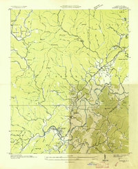
The French Broad River and its multiple forks converge near Rosman, forming a landscape defined by sharp elevation changes and deep mountain gaps. Surveyed in 1935, this sheet records a region in transition, where traditional mountain settlements like Balsam Grove and Cherryfield exist alongside New Deal-era infrastructure. The presence of CCC Camp No. F 14 and the State Prison Camp near Calvert suggests significant public works and forest management activity during the Great Depression.
Find a feature on this map
61 named features on this map. Tap any name to fly to it.
Don’t see what you’re looking for? This feature index may not catch every label — zoom into the map to look around manually.
Map Details
Editions of this 1935 Rosman Map
This is the sole edition of this map. No revisions or reprints were ever made.
Other maps of this area

1905 · Pisgah
USGS Topo · 1:125,000

1906 · Pisgah
USGS Topo · 1:125,000

1935 · Brevard
USGS Topo · 1:24,000

1935 · Eastatoe Gap
USGS Topo · 1:24,000

1935 · Sam Knob
USGS Topo · 1:24,000

1935 · Lake Toxaway
USGS Topo · 1:24,000

1935 · Reid
USGS Topo · 1:24,000

1935 · Table Rock
USGS Topo · 1:24,000

1935 · Shining Rock
USGS Topo · 1:24,000

1935 · Pisgah Forest
USGS Topo · 1:24,000