1990s Maps of Tyrrell County, North Carolina
Explore 4 historic maps of Tyrrell County from the 1990s. These maps offer a rare glimpse into what life looked like during the 1990s — showing old roads, neighborhoods, homes, and landmarks that have changed or disappeared over time.
Whether you're researching your family's past, planning a metal detecting trip, or studying how Tyrrell County's landscape evolved across the 1990s, these high-resolution maps are a powerful tool for exploring the history of this region.
- Focus on a specific era: All maps on this page are from the 1990s, giving you a focused view of this time period.
- See what’s changed: Compare century-old streets, trails, and buildings to today's modern landscape using overlays and satellite layers.
- Research with precision: Use these maps for genealogy, historical research, land use analysis, or educational projects.
- View, download, or print: Maps are fully viewable online in high resolution, and can be downloaded or printed for your own records.
Start exploring Tyrrell County's history through authentic maps from the 1990s. This is your window into the past.
Tyrrell County, NC maps
(4)- 1997 Map of Stevenson Point, 2000 Print
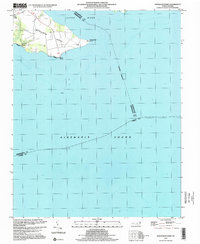 1997 Stevenson Point2000 Print · USGSThe coastal reaches of Perquimans County are captured here in the late nineties as they front the sound. Genealogists and local historians can trace the shoreline of Durants Neck from Leighs Temple down to the Seawall at Reed Point.
 - 1998 Map of Columbia West, 2001 Print
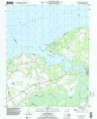 1998 Columbia West2001 Print · USGSCoastal Tyrrell County comes to life on the shores of the Albemarle Sound just before the turn of the millennium. Researchers can trace riverfront heritage through sites like Columbia, Chapel Hill Missionary Church, and Simmons Landing.
 - 1998 Map of Columbia East, 2001 Print
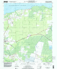 1998 Columbia East2001 Print · USGSThe northern coast of Tyrrell County is documented in the late nineties, showcasing the intersection of swampland and shore near Columbia. Researchers can locate family landmarks like Malachi Chapel, Missionary Ch, and the schools serving Newfoundland.
 - 1999 Map of Point Harbor, 2002 Print
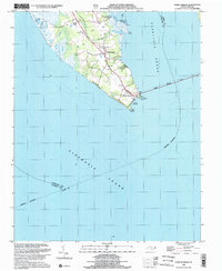 1999 Point Harbor2002 Print · USGSThe Currituck peninsula at the turn of the millennium shows the vital gateway between the northern sounds and the Outer Banks. Researchers can trace local landmarks like Piney Grove Ch and Powells Point or follow the path of the Wright Memorial Bridge.
End of results
Showing maps 1-4 of 4
Top cities of Tyrrell County
Frequently asked questions
- What are the different types of historical maps available for Tyrrell County?
- What is the oldest map of Tyrrell County?
- Where can I purchase historical maps of Tyrrell County for my home or office?
- Where can I download high-res historical maps of Tyrrell County?
- Are there historical topographic maps available for Tyrrell County?
- Is there historical aerial imagery available for Tyrrell County?
- Where are historical maps of Tyrrell County sourced from?