1970s Maps of Union County, North Carolina
Explore 16 historic maps of Union County from the 1970s. These maps offer a rare glimpse into what life looked like during the 1970s — showing old roads, neighborhoods, homes, and landmarks that have changed or disappeared over time.
Whether you're researching your family's past, planning a metal detecting trip, or studying how Union County's landscape evolved across the 1970s, these high-resolution maps are a powerful tool for exploring the history of this region.
- Focus on a specific era: All maps on this page are from the 1970s, giving you a focused view of this time period.
- See what’s changed: Compare century-old streets, trails, and buildings to today's modern landscape using overlays and satellite layers.
- Research with precision: Use these maps for genealogy, historical research, land use analysis, or educational projects.
- View, download, or print: Maps are fully viewable online in high resolution, and can be downloaded or printed for your own records.
Start exploring Union County's history through authentic maps from the 1970s. This is your window into the past.
Union County, NC maps
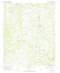
(16)- 1970 Map of Watson, 1973 Print
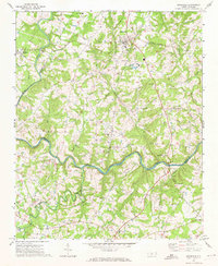
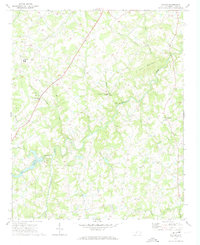 1970 Watson1973 Print · USGSUnion County, North Carolina, is depicted here in the early seventies as a landscape of small farming communities and winding creeks. Genealogists and local historians can trace family roots through numerous sites like Shiloh Ch, Fairfield, and the Williams Cem.2 unique versions available
 - 1970 Map of Marshville, 1973 Print
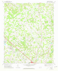
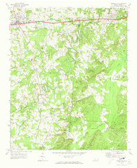 1970 Marshville1973 Print · USGSThe northern Piedmont at the start of the 1970s shows the transition from a rail-dependent economy to a highway-driven one. Genealogists can locate family landmarks such as Sturdivants Crossroads, Pine View Cem, and the rural Meltonville Ch.2 unique versions available
 - 1970 Map of Wingate, 1973 Print
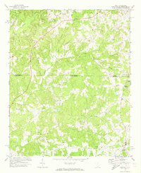
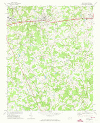 1970 Wingate1973 Print · USGSUnion County during the early 1970s shows the expansion of eastern MONROE and the growth of the Wingate College campus. Genealogists and local historians can trace family locations near Rock Rest, Allens Crossroads, or rural sites like Nicey Grove Ch.2 unique versions available
 - 1970 Map of Waxhaw, 1973 Print
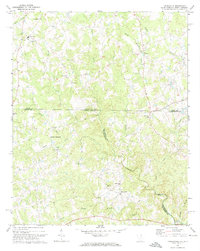
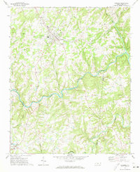
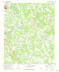
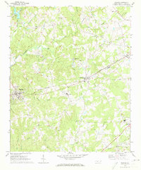 1970 Waxhaw1973 Print · USGSUnion County, North Carolina, appears here in the early 1970s as a rural landscape shaped by the rail line and a dense network of creeks. Researchers can locate several community landmarks including Western Union School, Liberty Hill Church, and the Old Railroad Grade.3 unique versions available
 - 1970 Map of Olive Branch, 1973 Print
 1970 Olive Branch1973 Print · USGSCrossing the border between Union and Anson counties in the early seventies, this area shows a landscape defined by small farming communities and winding creek branches. Researchers can locate family landmarks such as Baucoms Cem, Zion Crossroad Ch, and Rebel Hill.
 - 1971 Map of Bakers, 1973 Print
 1971 Bakers1973 Print · USGSUnion County's rural crossroads and emerging suburbs are documented here in the early 1970s as the area around Monroe began to expand. Researchers can locate specific family landmarks including Union Grove Ch, the SEABOARD COAST LINE railway, and Bentons Crossroads.3 unique versions available
 - 1971 Map of Unity, 1973 Print
 1971 Unity1973 Print · USGSThe Carolina borderlands in Lancaster and Union counties are captured here in the early 1970s, showcasing a landscape of rural settlements and branch-water farms. Genealogists can trace family footprints through community hubs like Unity, Sapps Crossroads, and Lingles Crossroads.3 unique versions available
 - 1971 Map of Tradesville, 1973 Print
 1971 Tradesville1973 Print · USGSThe Carolina borderlands come to life in this early 1970s survey of the rural landscape between Lancaster and Chesterfield counties. Genealogists can trace family roots through numerous community landmarks like Tabernacle Ch, Prospect Sch, and Stewart Crossroads.
 - 1971 Map of Pageland, 1973 Print
 1971 Pageland1973 Print · USGSThe borderlands of the Carolinas are captured in the early seventies, centered on the growing town of Pageland. Genealogists and local historians can trace rural family landmarks like the Blakeney Cemetery, the Petersburg School, and Liberty Hill Ch.2 unique versions available
 - 1971 Map of Midland, 1973 Print
 1971 Midland1973 Print · USGSMidland and the surrounding Piedmont countryside are captured in the early seventies as the region maintained its rural character. Genealogists can trace family landmarks at Mill Grove Ch Cem, Clear Creek Ch, and the crossroads at Brief.3 unique versions available
 - 1971 Map of Hornsboro, 1973 Print
 1971 Hornsboro1973 Print · USGSCrossing the North and South Carolina border in the early seventies, this survey shows the rural character of the land between Pageland and Hornsboro. Researchers can trace the locations of historic country churches like Wesley Chapel and the Hutsey Millpond.2 unique versions available
 - 1971 Map of Monroe, 1973 Print
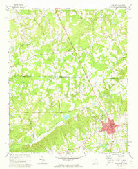
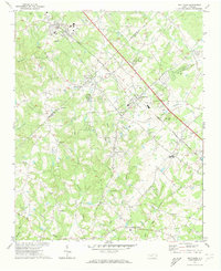
 1971 Monroe1973 Print · USGSMonroe was expanding as a regional hub in the early seventies, centered on a busy rail corridor and a network of rural crossroads. Local historians can trace family land near Roughedge, Alton, and several country churches like New Hope Church and Macedonia Church.2 unique versions available
 - 1971 Map of Stanfield, 1973 Print
 1971 Stanfield1973 Print · USGSThe rural Piedmont region of North Carolina comes into focus here in the early seventies, centered on the Rocky River borderlands. Genealogists and local historians can locate numerous country congregations including Philadelphia Ch, Antioch Ch, and Loves Chapel Ch.2 unique versions available
 - 1971 Map of Matthews, 1973 Print
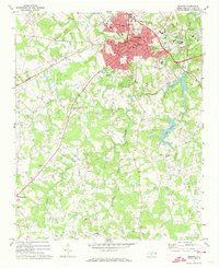
 1971 Matthews1973 Print · USGSSoutheast of Charlotte in the early 1970s, the rail-oriented communities of Union Co and Mecklenburg Co are caught in a moment of rapid suburban expansion. Local historians can trace old family church locations like Hudson Grove Ch and Maple Grove Ch alongside the busy Seaboard Coast Line.3 unique versions available
 - 1971 Map of Oakboro, 1973 Print
 1971 Oakboro1973 Print · USGSStanly and Union counties meet along the Rocky River in the early 1970s, where the Norfolk Southern rail line connects rural crossroads. Genealogists can trace family roots at Oakboro Cem, Big Lick, and Mt Moriah Ch.
 - 1971 Map of Mint Hill, 1973 Print
 1971 Mint Hill1973 Print · USGSEastern Mecklenburg County is shown in the early seventies as small towns like Mint Hill and Wilgrove began to feel the outward expansion of Charlotte. Researchers can trace genealogical roots through dozens of local landmarks, including Philadelphia Ch, Logan Chapel, and Bain Sch.3 unique versions available
End of results
Showing maps 1-16 of 16
Top cities of Union County
- Monroe historical maps
- Indian Trail historical maps
- Waxhaw historical maps
- Weddington historical maps
- Unionville historical maps
- Fairview historical maps
See more
Frequently asked questions
- What are the different types of historical maps available for Union County?
- What is the oldest map of Union County?
- Where can I purchase historical maps of Union County for my home or office?
- Where can I download high-res historical maps of Union County?
- Are there historical topographic maps available for Union County?
- Is there historical aerial imagery available for Union County?
- Where are historical maps of Union County sourced from?