1970s Maps of Bobbitt, North Carolina
Explore 1 historic maps of Bobbitt from the 1970s. These maps offer a rare glimpse into what life looked like during the 1970s — showing old roads, neighborhoods, homes, and landmarks that have changed or disappeared over time.
Whether you're researching your family's past, planning a metal detecting trip, or studying how Bobbitt's landscape evolved across the 1970s, these high-resolution maps are a powerful tool for exploring the history of this region.
- Focus on a specific era: All maps on this page are from the 1970s, giving you a focused view of this time period.
- See what’s changed: Compare century-old streets, trails, and buildings to today's modern landscape using overlays and satellite layers.
- Research with precision: Use these maps for genealogy, historical research, land use analysis, or educational projects.
- View, download, or print: Maps are fully viewable online in high resolution, and can be downloaded or printed for your own records.
Start exploring Bobbitt's history through authentic maps from the 1970s. This is your window into the past.
Bobbitt, NC maps
(1)- 1979 Map of Kittrell
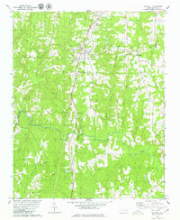 1979 Kittrell1979 Print · USGSVance and Franklin counties appear here in the late seventies as the rural landscape centered on the Seaboard Coast Line corridor. Genealogists can locate family landmarks like St Marys Ch, Kittrell Junior College, and the small settlement of Bobbitt.
End of results
Showing maps 1-1 of 1
Top cities near Bobbitt
- Wake Forest historical maps
- Henderson historical maps
- Oxford historical maps
- Louisburg historical maps
- Creedmoor historical maps
- Youngsville historical maps
See more
Frequently asked questions
- What are the different types of historical maps available for Bobbitt?
- What is the oldest map of Bobbitt?
- Where can I purchase historical maps of Bobbitt for my home or office?
- Where can I download high-res historical maps of Bobbitt?
- Are there historical topographic maps available for Bobbitt?
- Is there historical aerial imagery available for Bobbitt?
- Where are historical maps of Bobbitt sourced from?