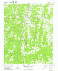
1979 Map of Kittrell
USGS Topo · Published 1979About this map
The Seaboard Coast Line railroad dictates the north-south axis of this landscape, cutting through the community of Kittrell and past the historic campus of Kittrell Junior College. This 1970s survey documents a rural environment where development is clustered along the rail line and the transition from Vance Co to Franklin Co. The southern portion of the map is defined by the winding course of the Tar River, which receives numerous tributaries including Billys Creek and Middle Creek. Local social centers are well-represented by a network of country churches such as St Marys Ch, Plank Chapel, and Oak Ridge Ch. The topography is characterized by the dissected drainage basins of Tabbs Creek and Buffalo Creek, illustrating the traditional land-use patterns of the North Carolina Piedmont prior to more recent suburban expansion.
Find a feature on this map
27 named features on this map. Tap any name to fly to it.
Don’t see what you’re looking for? This feature index may not catch every label — zoom into the map to look around manually.
Map Details
Editions of this 1979 Kittrell Map
This is the sole edition of this map. No revisions or reprints were ever made.
Other maps of this area

1943 · Creedmoor
USGS Topo · 1:62,500

1944 · Creedmoor
USGS Topo · 1:62,500

1953 · Oxford
USGS Topo · 1:62,500

1953 · Greensboro
USGS Topo · 1:250,000

1954 · Greensboro
USGS Topo · 1:250,000

1962 · Greensboro
USGS Topo · 1:250,000

1966 · Greensboro
USGS Topo · 1:250,000

1966 · Oxford
USGS Topo · 1:62,500

1970 · Vicksboro
USGS Topo · 1:24,000

1970 · Henderson
USGS Topo · 1:24,000