
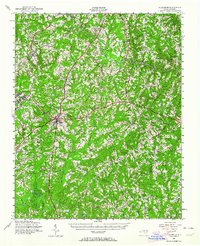
1943 Map of Creedmoor
USGS Topo · Published 1957About this map
The Camp Butner Military Reservation dominates the western edge of this Granville County landscape during the height of the second World War. This 1943 survey shows the intersection of military preparation and established rural life, where the Seaboard Air Line railroad connects the bustling hub of Creedmoor to surrounding communities like Stem and Hester. The terrain is defined by the winding paths of the Tar River and Beaverdam Creek, which dictated the early placement of family-named settlements and crossroads.
Find a feature on this map
69 named features on this map. Tap any name to fly to it.
Don’t see what you’re looking for? This feature index may not catch every label — zoom into the map to look around manually.
Map Details
Editions of this 1943 Creedmoor Map
2 editions found
Other maps of this area

1943 · Durham South
USGS Topo · 1:62,500

1943 · Raleigh
USGS Topo · 1:62,500

1943 · Roxboro
USGS Topo · 1:62,500

1944 · Creedmoor
USGS Topo · 1:62,500

1951 · Raleigh
USGS Topo · 1:62,500

1951 · Durham South
USGS Topo · 1:62,500

1951 · Durham North
USGS Topo · 1:62,500

1953 · Oxford
USGS Topo · 1:62,500

1953 · Raleigh
USGS Topo · 1:250,000

1953 · Greensboro
USGS Topo · 1:250,000