1970s Maps of Flat Rock, North Carolina
Explore 2 historic maps of Flat Rock from the 1970s. These maps offer a rare glimpse into what life looked like during the 1970s — showing old roads, neighborhoods, homes, and landmarks that have changed or disappeared over time.
Whether you're researching your family's past, planning a metal detecting trip, or studying how Flat Rock's landscape evolved across the 1970s, these high-resolution maps are a powerful tool for exploring the history of this region.
- Focus on a specific era: All maps on this page are from the 1970s, giving you a focused view of this time period.
- See what’s changed: Compare century-old streets, trails, and buildings to today's modern landscape using overlays and satellite layers.
- Research with precision: Use these maps for genealogy, historical research, land use analysis, or educational projects.
- View, download, or print: Maps are fully viewable online in high resolution, and can be downloaded or printed for your own records.
Start exploring Flat Rock's history through authentic maps from the 1970s. This is your window into the past.
Flat Rock, NC maps
(2)- 1970 Map of Middleburg, 1973 Print
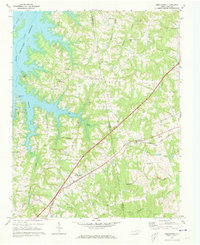 1970 Middleburg1973 Print · USGSVance and Warren counties are shown here in the early 1970s as the regional landscape adjusted to the reservoir shoreline and the development of Soul City. Researchers can trace local heritage through the Seaboard Coast Line rail stops and rural landmarks like Nutbush Sch and Morning Star Ch.2 unique versions available
 - 1977 Map of Middleburg, 1978 Print
 1977 Middleburg1978 Print · USGSThe North Carolina countryside appears in sharp detail in the late 1970s, showing the intersection of agricultural life and major transit lines. Researchers can trace the footprints of Middleburg, Manson, and Drewry alongside the John H Kerr Reservoir.
End of results
Showing maps 1-2 of 2
Top cities near Flat Rock
- Henderson historical maps
- Oxford historical maps
- Clarksville historical maps
- Norlina historical maps
- Warrenton historical maps
- Kittrell historical maps
See more
Frequently asked questions
- What are the different types of historical maps available for Flat Rock?
- What is the oldest map of Flat Rock?
- Where can I purchase historical maps of Flat Rock for my home or office?
- Where can I download high-res historical maps of Flat Rock?
- Are there historical topographic maps available for Flat Rock?
- Is there historical aerial imagery available for Flat Rock?
- Where are historical maps of Flat Rock sourced from?