1950s Maps of Lovill, North Carolina
Explore 3 historic maps of Lovill from the 1950s. These maps offer a rare glimpse into what life looked like during the 1950s — showing old roads, neighborhoods, homes, and landmarks that have changed or disappeared over time.
Whether you're researching your family's past, planning a metal detecting trip, or studying how Lovill's landscape evolved across the 1950s, these high-resolution maps are a powerful tool for exploring the history of this region.
- Focus on a specific era: All maps on this page are from the 1950s, giving you a focused view of this time period.
- See what’s changed: Compare century-old streets, trails, and buildings to today's modern landscape using overlays and satellite layers.
- Research with precision: Use these maps for genealogy, historical research, land use analysis, or educational projects.
- View, download, or print: Maps are fully viewable online in high resolution, and can be downloaded or printed for your own records.
Start exploring Lovill's history through authentic maps from the 1950s. This is your window into the past.
Lovill, NC maps
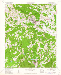
(3)- 1953 Map of Winston-Salem, 1974 Print
 1953 Winston-Salem1974 Print · USGSThe North Carolina Piedmont and Virginia highlands meet in the mid-1950s, a landscape defined by the tobacco and textile hubs of the Blue Ridge foothills. Researchers can trace the rail-and-river geography connecting Winston-Salem to mountain towns like Mount Airy and Galax.2 unique versions available
 - 1955 Map of Winston-Salem
 1955 Winston-Salem1955 Print · USGSThe Central Blue Ridge and Piedmont transition are captured here in the mid-fifties, from the industrial hub of Winston-Salem to the high peaks of Southwest Virginia. Genealogists can trace family landmarks like Richmond Hill Ch, Siloam Ch, and the old rail stops along the Southern Railway.
 - 1959 Map of Boone, 1962 Print
 1959 Boone1962 Print · USGSWatauga County at the end of the fifties reveals a growing mountain landscape centered on the college town of Boone. Genealogists and historians can trace family cemeteries like Adams Cem and Vannoy Cem or explore early recreation sites at Chetola Lake and Camp Sky Ranch.5 unique versions available
End of results
Showing maps 1-3 of 3
Top cities near Lovill
- Boone historical maps
- Mountain City historical maps
- Blowing Rock historical maps
- West Jefferson historical maps
- Banner Elk historical maps
- Newland historical maps
See more
Frequently asked questions
- What are the different types of historical maps available for Lovill?
- What is the oldest map of Lovill?
- Where can I purchase historical maps of Lovill for my home or office?
- Where can I download high-res historical maps of Lovill?
- Are there historical topographic maps available for Lovill?
- Is there historical aerial imagery available for Lovill?
- Where are historical maps of Lovill sourced from?