1970s Maps of Goldsboro, North Carolina
Explore 2 historic maps of Goldsboro from the 1970s. These maps offer a rare glimpse into what life looked like during the 1970s — showing old roads, neighborhoods, homes, and landmarks that have changed or disappeared over time.
Whether you're researching your family's past, planning a metal detecting trip, or studying how Goldsboro's landscape evolved across the 1970s, these high-resolution maps are a powerful tool for exploring the history of this region.
- Focus on a specific era: All maps on this page are from the 1970s, giving you a focused view of this time period.
- See what’s changed: Compare century-old streets, trails, and buildings to today's modern landscape using overlays and satellite layers.
- Research with precision: Use these maps for genealogy, historical research, land use analysis, or educational projects.
- View, download, or print: Maps are fully viewable online in high resolution, and can be downloaded or printed for your own records.
Start exploring Goldsboro's history through authentic maps from the 1970s. This is your window into the past.
Goldsboro, NC maps
(2)- 1974 Map of Northwest Goldsboro, 1976 Print
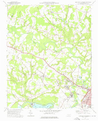 1974 Northwest Goldsboro1976 Print · USGSWayne County just west of Goldsboro in the mid-1970s reveals a landscape of expanding institutional campuses and rural crossroads. Local historians can trace the grounds of CHERRY HOSPITAL, the community at Rosewood, and family landmarks like Spring Hill Ch.2 unique versions available
 - 1974 Map of Southwest Goldsboro, 1976 Print
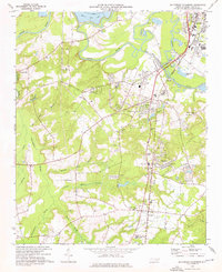 1974 Southwest Goldsboro1976 Print · USGSWayne County in the mid-seventies is a landscape of river-bottom swamps and growing rural towns along the rail lines. Genealogists can trace family landmarks and congregations from Dudley up to Genoa, including St Matthews Ch, Augusta Ch, and the Wayne Mem Park.2 unique versions available
End of results
Showing maps 1-2 of 2
Top cities near Goldsboro
- Mount Olive historical maps
- La Grange historical maps
- Fremont historical maps
- Kenly historical maps
- Princeton historical maps
- Walnut Creek historical maps
See more
Top neighborhoods of Goldsboro
- Adamsville historical maps
- Airboro historical maps
- Seymour Johnson Homes historical maps
- Green Meadows historical maps
- Hillcrest Farm historical maps
- McArthur Manor historical maps
See more
Frequently asked questions
- What are the different types of historical maps available for Goldsboro?
- What is the oldest map of Goldsboro?
- Where can I purchase historical maps of Goldsboro for my home or office?
- Where can I download high-res historical maps of Goldsboro?
- Are there historical topographic maps available for Goldsboro?
- Is there historical aerial imagery available for Goldsboro?
- Where are historical maps of Goldsboro sourced from?