1930s Maps of Possumtrot, North Carolina
Explore 2 historic maps of Possumtrot from the 1930s. These maps offer a rare glimpse into what life looked like during the 1930s — showing old roads, neighborhoods, homes, and landmarks that have changed or disappeared over time.
Whether you're researching your family's past, planning a metal detecting trip, or studying how Possumtrot's landscape evolved across the 1930s, these high-resolution maps are a powerful tool for exploring the history of this region.
- Focus on a specific era: All maps on this page are from the 1930s, giving you a focused view of this time period.
- See what’s changed: Compare century-old streets, trails, and buildings to today's modern landscape using overlays and satellite layers.
- Research with precision: Use these maps for genealogy, historical research, land use analysis, or educational projects.
- View, download, or print: Maps are fully viewable online in high resolution, and can be downloaded or printed for your own records.
Start exploring Possumtrot's history through authentic maps from the 1930s. This is your window into the past.
Possumtrot, NC maps
(2)- 1935 Map of Bald Creek
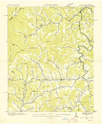 1935 Bald Creek1935 Print · USGSWestern North Carolina's high country is captured here in the mid-1930s, documenting the remote mountain valleys and ridge-top borders of Yancey County. Genealogists can trace family homes near Possumtrot, Bee Log, and rural schools like Horton Hill Sch.
 - 1939 Map of Bald Creek
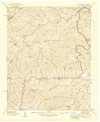 1939 Bald Creek1939 Print · USGSThe North Carolina and Tennessee borderlands appear here in the late 1930s, showing a rugged landscape of high peaks and river-valley settlements. Genealogists can locate family landmarks like Cane River (P.O.), Piney Grove Sch, and Robinson Cem during an era when the Appalachian Trail was newly established.7 unique versions available
End of results
Showing maps 1-2 of 2
Top cities near Possumtrot
- Erwin historical maps
- Weaverville historical maps
- Mars Hill historical maps
- Burnsville historical maps
- Marshall historical maps
- Green Mountain historical maps
Frequently asked questions
- What are the different types of historical maps available for Possumtrot?
- What is the oldest map of Possumtrot?
- Where can I purchase historical maps of Possumtrot for my home or office?
- Where can I download high-res historical maps of Possumtrot?
- Are there historical topographic maps available for Possumtrot?
- Is there historical aerial imagery available for Possumtrot?
- Where are historical maps of Possumtrot sourced from?