1960s Maps of Getchell Township, North Dakota
Explore 5 historic maps of Getchell Township from the 1960s. These maps offer a rare glimpse into what life looked like during the 1960s — showing old roads, neighborhoods, homes, and landmarks that have changed or disappeared over time.
Whether you're researching your family's past, planning a metal detecting trip, or studying how Getchell Township's landscape evolved across the 1960s, these high-resolution maps are a powerful tool for exploring the history of this region.
- Focus on a specific era: All maps on this page are from the 1960s, giving you a focused view of this time period.
- See what’s changed: Compare century-old streets, trails, and buildings to today's modern landscape using overlays and satellite layers.
- Research with precision: Use these maps for genealogy, historical research, land use analysis, or educational projects.
- View, download, or print: Maps are fully viewable online in high resolution, and can be downloaded or printed for your own records.
Start exploring Getchell Township's history through authentic maps from the 1960s. This is your window into the past.
Getchell Township, ND maps
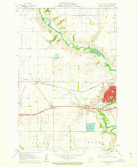
(5)- 1961 Map of Valley City East, 1962 Print
 1961 Valley City East1962 Print · USGSThe Sheyenne River valley and the expanding rail-and-highway corridor of Barnes County are captured here in the early sixties. Genealogists can locate several family resting places such as Hillside Cem and Memory Gardens Cem, or trace the tracks of the Soo Line.
 - 1961 Map of Baldhill Dam, 1963 Print
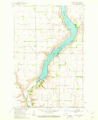 1961 Baldhill Dam1963 Print · USGSThe Sheyenne River valley was undergoing major changes in the early sixties as the Missouri River Basin development took shape. Genealogists and historians can locate rural landmarks like Zion Ch, Logan Sch, and the operations at the Baldhill Dam.
 - 1961 Map of Valley City West, 1963 Print
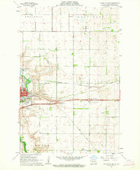
 1961 Valley City West1963 Print · USGSValley City and its surrounding townships are shown here during the early sixties as a bustling rail and educational center. Genealogists can locate family landmarks such as Heimes Sch, Woodbine Cem, and the campus of the State Teachers College.2 unique versions available
 - 1966 Map of Grand Forks
 1966 Grand Forks1966 Print · USGSThe Red River Valley in the mid-sixties shows a landscape shaped by rail-line commerce and complex water management. Genealogists and historians can trace rail-side towns like Emerado and Hunter or locate rural landmarks like the Pleasant View Church.
 - 1967 Map of Pillsbury SW, 1969 Print
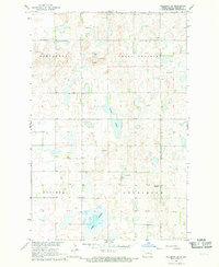 1967 Pillsbury SW1969 Print · USGSBarnes County's prairie wetlands and township divisions are captured here in the late sixties. Researchers can locate civic landmarks and family burial sites like the Townhall and Free Cem, or trace the shoreline of Adams Slough and Crow Lake.
End of results
Showing maps 1-5 of 5
Top cities near Getchell Township
- Valley City historical maps
- Sanborn historical maps
- Dazey historical maps
- Cuba historical maps
- Rogers historical maps
- Sibley historical maps
See more
Frequently asked questions
- What are the different types of historical maps available for Getchell Township?
- What is the oldest map of Getchell Township?
- Where can I purchase historical maps of Getchell Township for my home or office?
- Where can I download high-res historical maps of Getchell Township?
- Are there historical topographic maps available for Getchell Township?
- Is there historical aerial imagery available for Getchell Township?
- Where are historical maps of Getchell Township sourced from?