1960s Maps of Bismarck, North Dakota
Explore 2 historic maps of Bismarck from the 1960s. These maps offer a rare glimpse into what life looked like during the 1960s — showing old roads, neighborhoods, homes, and landmarks that have changed or disappeared over time.
Whether you're researching your family's past, planning a metal detecting trip, or studying how Bismarck's landscape evolved across the 1960s, these high-resolution maps are a powerful tool for exploring the history of this region.
- Focus on a specific era: All maps on this page are from the 1960s, giving you a focused view of this time period.
- See what’s changed: Compare century-old streets, trails, and buildings to today's modern landscape using overlays and satellite layers.
- Research with precision: Use these maps for genealogy, historical research, land use analysis, or educational projects.
- View, download, or print: Maps are fully viewable online in high resolution, and can be downloaded or printed for your own records.
Start exploring Bismarck's history through authentic maps from the 1960s. This is your window into the past.
Bismarck, ND maps
(2)- 1962 Map of Menoken SW, 1964 Print
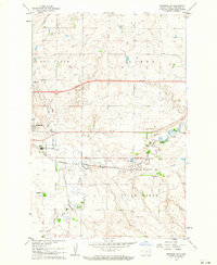 1962 Menoken SW1964 Print · USGSBismarck and the surrounding Gibbs Township are seen here in the early sixties as the city expanded eastward toward the Apple Creek valley. Genealogists and researchers can locate the State Penitentiary, rural schools like Wilson Sch, and the Fairview Cem alongside the Northern Pacific tracks.2 unique versions available
 - 1962 Map of Bismarck, 1964 Print
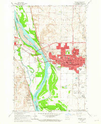 1962 Bismarck1964 Print · USGSBismarck and Mandan face each other across the Missouri River in the early 1960s during a period of significant capital expansion. Trace the historical roots of the region at the Fort Lincoln Historic Site Ruins, the Capitol grounds, and the Northern Pacific rail yards.3 unique versions available
End of results
Showing maps 1-2 of 2
Top cities near Bismarck
Top neighborhoods of Bismarck
- Century East historical maps
- Century Park historical maps
- Homan Acres historical maps
- Little Canada historical maps
- Memorial historical maps
- Pebble Creek historical maps
See more
Frequently asked questions
- What are the different types of historical maps available for Bismarck?
- What is the oldest map of Bismarck?
- Where can I purchase historical maps of Bismarck for my home or office?
- Where can I download high-res historical maps of Bismarck?
- Are there historical topographic maps available for Bismarck?
- Is there historical aerial imagery available for Bismarck?
- Where are historical maps of Bismarck sourced from?