1960s Maps of Ayr Township, North Dakota
Explore 5 historic maps of Ayr Township from the 1960s. These maps offer a rare glimpse into what life looked like during the 1960s — showing old roads, neighborhoods, homes, and landmarks that have changed or disappeared over time.
Whether you're researching your family's past, planning a metal detecting trip, or studying how Ayr Township's landscape evolved across the 1960s, these high-resolution maps are a powerful tool for exploring the history of this region.
- Focus on a specific era: All maps on this page are from the 1960s, giving you a focused view of this time period.
- See what’s changed: Compare century-old streets, trails, and buildings to today's modern landscape using overlays and satellite layers.
- Research with precision: Use these maps for genealogy, historical research, land use analysis, or educational projects.
- View, download, or print: Maps are fully viewable online in high resolution, and can be downloaded or printed for your own records.
Start exploring Ayr Township's history through authentic maps from the 1960s. This is your window into the past.
Ayr Township, ND maps
(5)- 1966 Map of Grand Forks
 1966 Grand Forks1966 Print · USGSThe Red River Valley in the mid-sixties shows a landscape shaped by rail-line commerce and complex water management. Genealogists and historians can trace rail-side towns like Emerado and Hunter or locate rural landmarks like the Pleasant View Church.
 - 1967 Map of Page SE, 1969 Print
 1967 Page SE1969 Print · USGSCass County agriculture and infrastructure are captured here in the late sixties as the Missouri River Basin program progressed. Researchers can trace the Great Northern rail corridor and locate early industrial sites like the local Sandpit across the townships of Cornell and Rich.
 - 1967 Map of Absaraka, 1969 Print
 1967 Absaraka1969 Print · USGSCass County agriculture and rail transit are on full display during the late sixties as the interstate highway system began to reshape the prairie. Genealogists can trace the rural hamlets of Absaraka and Magnolia or locate the Larson Landing Strip and regional Gravel Pit sites.
 - 1967 Map of Buffalo, 1969 Print
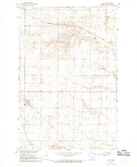
 1967 Buffalo1969 Print · USGSThe prairie landscape of western Cass County is centered on the railroad town of Buffalo during the late sixties. Genealogists and historians can trace the Northern Pacific rail line, the meanders of the Maple River, and local landmarks like the Grieve Landing Strip.
 - 1967 Map of Ayr, 1969 Print
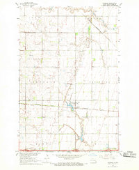
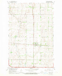
 1967 Ayr1969 Print · USGSThe grain-growing country of Cass County is captured here in the late sixties, centered on the railroad towns of Ayr and Erie. Researchers can trace the Great Northern rail lines or locate family landmarks like the Schroeder Landing Strip and Erie Cem.2 unique versions available
End of results
Showing maps 1-5 of 5
Top cities near Ayr Township
- Tower City historical maps
- Page historical maps
- Buffalo historical maps
- Wheatland historical maps
- Erie historical maps
- Everest Township historical maps
See more
Frequently asked questions
- What are the different types of historical maps available for Ayr Township?
- What is the oldest map of Ayr Township?
- Where can I purchase historical maps of Ayr Township for my home or office?
- Where can I download high-res historical maps of Ayr Township?
- Are there historical topographic maps available for Ayr Township?
- Is there historical aerial imagery available for Ayr Township?
- Where are historical maps of Ayr Township sourced from?