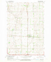
1967 Map of Buffalo
USGS Topo · Published 1969About this map
Buffalo serves as the central hub of this Cass County landscape, situated where the Northern Pacific railroad tracks cross the prairie. The town's layout is clearly defined against the surrounding agricultural townships of Tower, Buffalo, Hill, and Howes. The Maple River meanders through the western half of the survey area, its winding course providing a natural break in the geometric section lines that dominate the region.
Find a feature on this map
20 named features on this map. Tap any name to fly to it.
Don’t see what you’re looking for? This feature index may not catch every label — zoom into the map to look around manually.
Map Details
Editions of this 1967 Buffalo Map
This is the sole edition of this map. No revisions or reprints were ever made.
Other maps of this area

1895 · Casselton
USGS Topo · 1:125,000

1897 · Tower
USGS Topo · 1:125,000

1897 · Casselton
USGS Topo · 1:125,000

1952 · Grand Forks
USGS Topo · 1:250,000

1953 · Fargo
USGS Topo · 1:250,000

1956 · Fargo
USGS Topo · 1:250,000

1956 · Grand Forks
USGS Topo · 1:250,000

1965 · Alice
USGS Topo · 1:24,000

1965 · Tower City SW
USGS Topo · 1:24,000

1966 · Grand Forks
USGS Topo · 1:250,000