1960s Maps of Pontiac Township, North Dakota
Explore 2 historic maps of Pontiac Township from the 1960s. These maps offer a rare glimpse into what life looked like during the 1960s — showing old roads, neighborhoods, homes, and landmarks that have changed or disappeared over time.
Whether you're researching your family's past, planning a metal detecting trip, or studying how Pontiac Township's landscape evolved across the 1960s, these high-resolution maps are a powerful tool for exploring the history of this region.
- Focus on a specific era: All maps on this page are from the 1960s, giving you a focused view of this time period.
- See what’s changed: Compare century-old streets, trails, and buildings to today's modern landscape using overlays and satellite layers.
- Research with precision: Use these maps for genealogy, historical research, land use analysis, or educational projects.
- View, download, or print: Maps are fully viewable online in high resolution, and can be downloaded or printed for your own records.
Start exploring Pontiac Township's history through authentic maps from the 1960s. This is your window into the past.
Pontiac Township, ND maps
(2)- 1961 Map of Enderlin North, 1963 Print
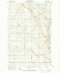
 1961 Enderlin North1963 Print · USGSThe borderlands of Cass and Ransom counties are captured here in the early sixties, centered on the growing town of Enderlin. Researchers can locate rural landmarks like Salem Cem, the NORTHERN PACIFIC rail line, and the winding course of the Maple River.
 - 1965 Map of Lucca, 1967 Print
 1965 Lucca1967 Print · USGSThe intersection of the Northern Pacific and Soo Line railroads defines the rural landscape of Barnes County in the 1960s. Trace the small settlement of Lucca, the Cem cemetery, and the winding course of the Maple River.
End of results
Showing maps 1-2 of 2
Top cities near Pontiac Township
- Lisbon historical maps
- Enderlin historical maps
- Sheldon historical maps
- Fingal historical maps
- Nome historical maps
- Coburn Township historical maps
See more
Frequently asked questions
- What are the different types of historical maps available for Pontiac Township?
- What is the oldest map of Pontiac Township?
- Where can I purchase historical maps of Pontiac Township for my home or office?
- Where can I download high-res historical maps of Pontiac Township?
- Are there historical topographic maps available for Pontiac Township?
- Is there historical aerial imagery available for Pontiac Township?
- Where are historical maps of Pontiac Township sourced from?